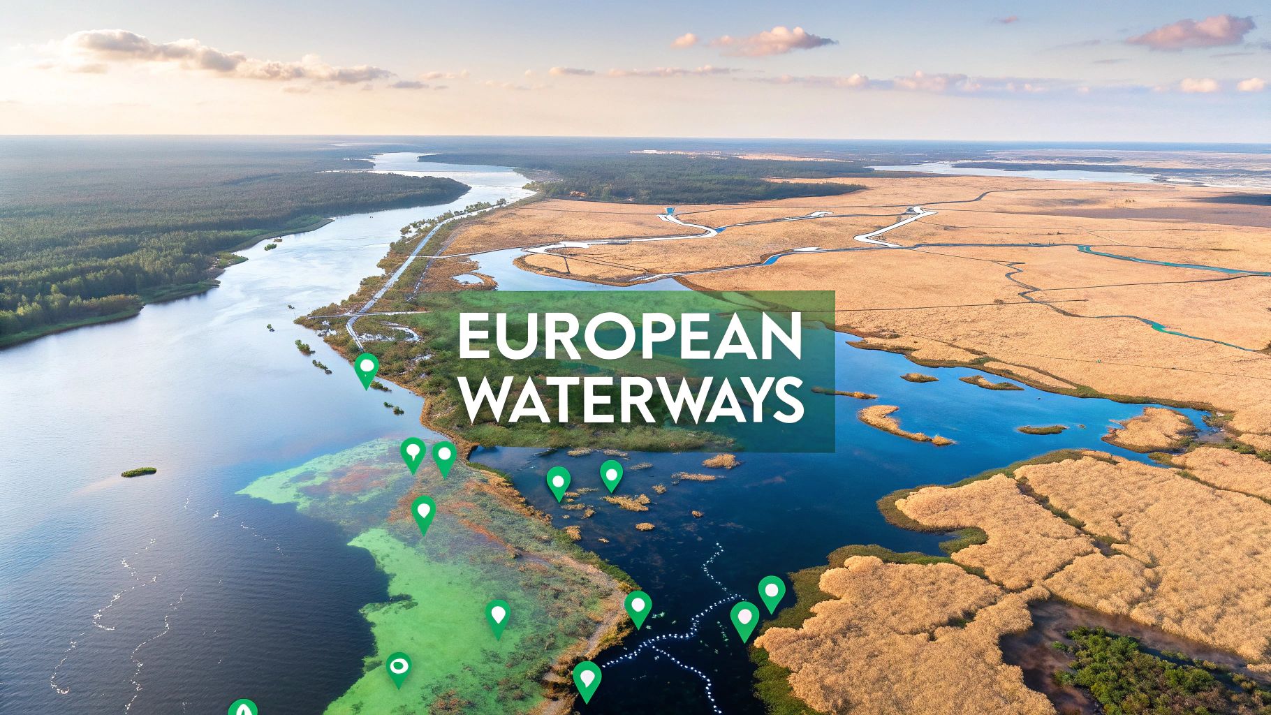
Explore Europe's Bodies of Water: A Geographic Journey
Discover the diverse bodies of water Europe offers, from rivers to lakes. Our guide highlights the key bodies of water Europe is known for. Click to learn more!
You can't talk about Europe without talking about its water.
From the ancient seas that cradled empires to the mighty rivers that fueled industrial revolutions, the vast network of bodies of water in Europe is the continent's true lifeblood. This guide will take you on a journey through this intricate system, showing you how water has carved landscapes, shaped cultures, and driven economies for thousands of years.
Exploring Europe's Intricate Waterways

To really get a feel for Europe, you have to look at its waters. They aren't just lines on a map; they're the veins and arteries that have nourished civilizations for millennia. Think of the continent less as a static chunk of land and more as a dynamic system where water dictates nearly everything, from local weather to global trade.
We'll start our journey with the major seas framing the continent—from the legendary Mediterranean to the stormy North Sea. These saltwater expanses were the original superhighways for trade, exploration, and conflict, setting the stage for the rise and fall of great powers. Their influence is still felt today in bustling port cities, regional cuisines, and coastal climates.
From Seas to Rivers
From the coast, we’ll head inland to navigate the great rivers like the Danube and the Rhine. These legendary waterways slice through the heart of the continent, acting as both natural borders and cultural bridges. Great cities like Vienna, Cologne, and Budapest owe their very existence to the rivers that flow through them. They were the engines of the Industrial Revolution and remain vital corridors for transport even now.
The story of Europe is written in its water. Each river, lake, and sea holds a chapter of history, telling tales of trade, conflict, and innovation that have shaped the continent's identity over thousands of years.
Of course, understanding this complex network today requires a modern toolkit. To see how geographers map and analyze these systems, it’s worth learning what Geographic Information Systems are and how they help visualize the flow and impact of water on the landscape. This technology reveals the hidden patterns that have been there all along.
Lakes and Man-Made Marvels
Finally, we'll explore the serene beauty of Europe's alpine lakes and the incredible ingenuity of its man-made canals. These features highlight the continent’s dual relationship with water, showcasing both nature’s artistry and humankind’s engineering prowess.
But the significance of these waterways extends beyond history and geography. For us, they play a huge role in gameplay and virtual exploration. In games like EarthChasers, these rivers and seas aren't just pretty scenery—they're key strategic elements.
They introduce unique challenges and opportunities for anyone navigating the digital continent:
- Strategic Navigation: Rivers and canals act as natural pathways or obstacles, forcing you to think carefully about your routes.
- Resource Management: Access to freshwater lakes and coastal areas can provide essential resources for in-game survival and growth.
- Cultural Discovery: Following these waterways often leads you straight to historically significant cities and landmarks, making the gameplay experience that much richer.
So, get ready to see Europe in a new light—not just as a collection of countries, but as a continent fundamentally shaped by its relationship with water.
The Seas That Frame the Continent

You can't really talk about Europe without talking about the sea. The continent's jagged, sprawling coastline is hugged by an incredible collection of seas, each with its own personality and historical significance. These aren't just passive boundaries on a map; they are powerful forces that have shaped trade routes, dictated climates, and set the stage for epic sagas of exploration and war.
To the west, the raw power of the Atlantic Ocean carves out the rugged cliffs of Ireland, Portugal, and Spain. Way up north, the icy breath of the Arctic Ocean defines the stark beauty of Scandinavia. These two giants feed a whole network of smaller, but no less important, European seas.
Every one of these seas has a story. The stormy North Sea was the playground of Viking longships. The much calmer Mediterranean served as the cradle of Western civilization, a liquid highway for Roman galleys and Venetian merchants. To get a real feel for Europe, you have to understand these massive marine environments.
The Historic Mediterranean and Black Seas
The Mediterranean is arguably the most historically important body of water on Earth. It was the great connector, linking the Egyptian, Greek, and Roman empires and allowing goods, ideas, and armies to flow freely. Its relatively calm waters were perfect for early seafaring, which is why so much culture and commerce exploded along its shores.
Tucked away and connected to the Med by the Bosphorus Strait is the Black Sea. For centuries, this huge inland sea has been a strategic crossroads between Europe and Asia. Its deep waters are anoxic—meaning they have no oxygen below a certain depth—which has created a unique ecosystem and preserved ancient shipwrecks in stunning condition for thousands of years.
The seas of Europe are more than just geographical features; they are living archives of history. From sunken Roman vessels in the Mediterranean to Viking trading posts on the Baltic coast, these waters hold tangible connections to the continent’s past.
These connected basins created a fluid world where cultures mingled, traded, and clashed. For a wider view on how these waters are categorized, you can explore the distinctions between different ocean and seas of the world to understand their place in the global picture.
The Baltic and North Seas
Head to Northern Europe, and you'll find the Baltic and North Seas, which have a completely different vibe. The Baltic Sea is one of the planet's largest bodies of brackish water—a mix of saltwater from the North Sea and freshwater from countless rivers. This low-salt environment supports a fragile ecosystem and has been a point of contention for centuries between powers like Sweden, Russia, and Germany.
The North Sea, on the other hand, is famous for its rough weather and incredible resources. Once a hub for fishing and trade for the Hanseatic League, it’s now one of the world's most important regions for offshore oil and gas. It remains strategically vital, hosting some of the busiest shipping lanes on the globe.
Modern Challenges Facing Europe's Seas
Today, these historic seas are facing very modern problems. Pollution, overfishing, and climate change are putting immense pressure on their marine ecosystems. Even acid rain, caused by industrial air pollution, can change the water's chemistry and harm aquatic life.
A few of the key environmental pressures include:
- Nutrient Runoff: Fertilizer and wastewater from farms and cities can trigger algal blooms that suck all the oxygen out of the water, creating "dead zones."
- Plastic Pollution: Trash from land and ships is a massive problem, harming wildlife and working its way into the food chain.
- Overfishing: Many fish stocks, especially in the North Sea and Mediterranean, are dangerously low, threatening both the ecosystem and the fishing industry.
Solving these problems requires countries to work together to protect the natural and historical heritage these seas represent. For EarthChasers players, these waters are dynamic gameplay arenas. They offer tough navigational challenges, hide valuable resources, and lead to historic port cities, making a solid understanding of Europe's maritime geography a key to success.
Great Rivers: The Arteries of Europe
If seas are the vast frames of the European continent, then its rivers are the arteries, pumping life into the heartland for thousands of years. These powerful waterways are far more than just lines on a map—they are the living chronicles of history, industry, and culture. They’ve carved out landscapes, nourished entire civilizations, and served as both highways for commerce and strategic lines of defense.
Legendary rivers like the Danube, Rhine, and Thames trace epic journeys from remote mountain springs all the way to sprawling deltas. It’s no coincidence that great cities like Vienna, Cologne, and London rose along their banks; their fortunes were directly tied to the flowing water beside them. These rivers became conduits for cultural exchange, carrying ideas, languages, and new ways of thinking from one region to another.
The Titans: Volga and Danube
When it comes to sheer scale, the Volga River is in a class of its own. As Europe's longest river, it winds through central Russia for an astonishing 3,530 kilometers (2,193 miles) before emptying into the Caspian Sea. The Volga is so fundamental to the nation's identity that it's often called "Mother Volga" in Russian folklore and literature.
The Danube is Europe's second-longest river and perhaps its most international. It flows through or borders ten different countries on its way to the Black Sea. This river has seen empires rise and fall, from the Romans who used it as a northern frontier to the Austro-Hungarian Empire that flourished along its banks. Today, the Danube remains a critical artery for trade, connecting the heart of Europe to the sea.
This chart really puts the size of these giants into perspective when compared to another major river, the Rhine.
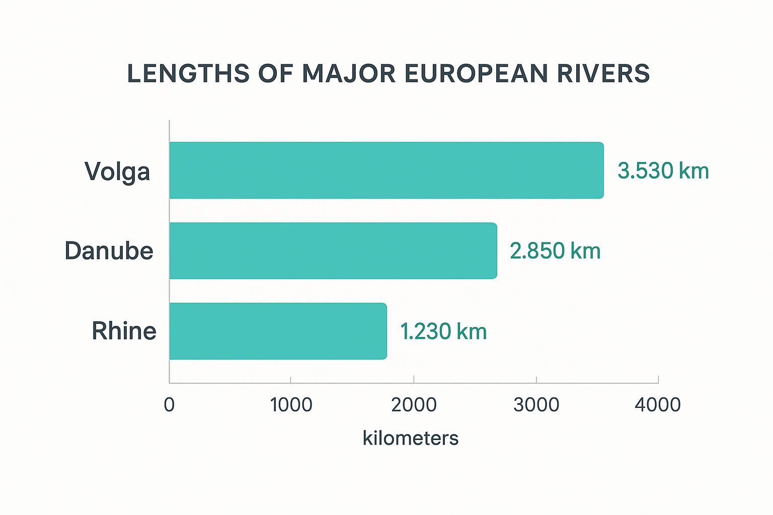
As you can see, the Volga absolutely dwarfs the others, measuring nearly three times the length of the Rhine.
The Rhine: A Commercial Powerhouse
The Rhine might be shorter than the Volga and Danube, but its economic and cultural impact is immense. Rising in the Swiss Alps, it flows north through Germany and the Netherlands into the North Sea, creating one of the most important industrial corridors in the world. Its route is dotted with iconic castles, terraced vineyards, and bustling port cities.
The Rhine’s character changes dramatically as it flows:
- Alpine Rhine: A fast-flowing mountain river carving through steep valleys.
- High Rhine: Forms the border between Switzerland and Germany, marked by the powerful Rhine Falls.
- Upper Rhine: Flows through a wide, flat valley—a major agricultural region.
- Middle Rhine: A UNESCO World Heritage Site, famous for its romantic castles and steep, vine-covered slopes.
- Lower Rhine: A broad, slow-moving river flowing through the heavily industrialized Ruhr region before fanning out into its delta in the Netherlands.
The Rhine and Moselle rivers are two of Europe's most scenic arteries, and you can see their beauty firsthand on a 15 Day Moutaintops Switzerland Rhine Moselle tour. A trip like this really highlights the stunning landscapes these rivers have created over millennia.
A river is more than an amenity, it is a treasure. It offers a necessity of life that must be rationed among those who have power over it. - Oliver Wendell Holmes, Jr.
This quote perfectly captures the strategic importance of rivers. For centuries, controlling these waterways meant controlling trade, transport, and resources. In a game like EarthChasers, this translates directly into gameplay. Securing a river crossing or establishing a settlement on a navigable river can provide a massive strategic advantage, offering access to resources and creating natural defenses. Understanding the flow and features of these great bodies of water in Europe is essential for any player looking to master the continent’s virtual landscape.
Europe's Most Spectacular Lakes
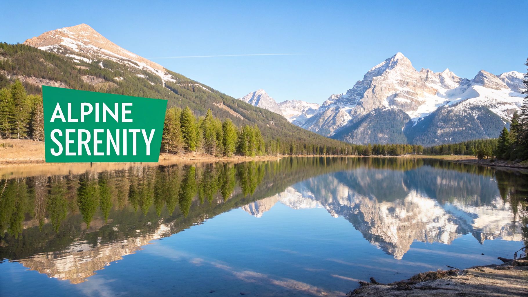
If seas frame the continent and rivers are its arteries, then Europe's lakes are its crown jewels. These still bodies of water are like mirrors, reflecting the continent's incredible geographic diversity—from the icy fjords of Scandinavia to the sun-drenched shores of Italy.
Each lake tells a unique geological story. Many were born from the brute force of ancient glaciers, which carved out deep valleys that later filled with meltwater. This process created the vast, deep lakes we see today in Sweden and Finland. Others, like the ancient lakes in the Balkans, were formed by tectonic activity that ripped the earth apart, creating massive basins.
But they're far more than just pretty scenery. These lakes serve as critical freshwater reservoirs, havens for biodiversity, and bustling hubs for recreation and tourism. They are vital pieces in the vast network of bodies of water in Europe.
The Grand Alpine Lakes
Tucked between towering peaks, the alpine lakes of Central Europe are postcard-perfect and world-famous. Lake Geneva, straddling the border of Switzerland and France, is a stunning crescent-shaped wonder fed by the Rhône river. It's easy to see why it has inspired artists and writers for centuries.
Head south, and you’ll find Italy's Lake Como, a playground for the rich and famous whose dramatic beauty is undeniable. Its unique Y-shape offers breathtaking views from almost every angle, with charming villages clinging to its steep, wooded slopes. Both are classic examples of glacial action, sculpted by immense ice flows during the last Ice Age.
Northern Europe's Lakeland Regions
Scandinavia and the British Isles offer a completely different, wilder lake experience. Finland, often called the "Land of a Thousand Lakes," is a stunning mosaic of water and forest. Here, lakes like Saimaa aren't just single bodies of water; they are sprawling, interconnected systems of channels and islands best explored by boat.
Scotland's lochs, also carved by glaciers, are famous for their deep, mysterious waters and rugged beauty. Loch Lomond, the largest lake in Great Britain by surface area, is a cornerstone of Scottish culture. The scenery is so spectacular that people are always finding new ways to experience it; you can even learn about paddleboarding on Loch Lomond and neighboring lochs to see these waters from a totally new perspective.
To give you a clearer picture, here's a quick look at some of Europe's most significant lakes.
Major European Lakes at a Glance
| Lake Name | Country/Countries | Surface Area (km²) | Type |
|---|---|---|---|
| Lake Ladoga | Russia | 17,700 | Freshwater |
| Lake Onega | Russia | 9,700 | Freshwater |
| Lake Vänern | Sweden | 5,650 | Freshwater |
| Lake Saimaa | Finland | 4,400 | Freshwater |
| Lake Peipus | Estonia, Russia | 3,555 | Freshwater |
| Lake Geneva | Switzerland, France | 580 | Glacial |
| Lake Como | Italy | 146 | Glacial |
This table just scratches the surface, but it highlights the sheer scale and diversity of these incredible natural landmarks.
Protecting Fragile Ecosystems
Europe's freshwater ecosystems are both vast and vulnerable. We're talking about approximately 1.3 million kilometers of river length and 84,000 square kilometers of lake surface across the EU-28 alone.
Despite their importance, these habitats face intense pressure from over-exploitation and pollution. While things have improved since the 1970s thanks to better wastewater management, progress has slowed. The health of these lakes acts as an early warning system for the entire continent.
Lakes act as the planet's sentinels. Their ecosystems are incredibly sensitive to environmental changes, making them powerful indicators of regional and global health. A change in a lake's water quality can signal broader problems like air pollution or climate shifts.
Current conservation efforts are focused on a few key areas to protect these invaluable resources for future generations:
- Reducing Pollution: Implementing stricter rules on agricultural runoff and industrial discharge to keep harmful chemicals out.
- Restoring Habitats: Bringing back shoreline vegetation and reintroducing native species to bolster the lake's natural defenses.
- Sustainable Tourism: Promoting responsible recreation to minimize the human footprint while still allowing people to enjoy these natural wonders.
For EarthChasers players, these lakes are more than just beautiful locations. They are vital strategic points on the map—essential freshwater sources, natural barriers, and areas ripe for discovery. A solid understanding of their geography gives you a serious advantage in the game.
Navigating Europe's Man-Made Canals
Embedded content
While nature carved out Europe’s great rivers and lakes, human ingenuity added another layer entirely. Long before railways and highways, a sprawling network of man-made canals was engineered to connect natural river systems, creating artificial arteries for trade and transport.
These canals were the lifeblood of the early industrial age. Imagine trying to haul heavy loads of coal or grain across a continent using only muddy roads and horse-drawn carts. It was slow and incredibly inefficient. Canals changed everything. By linking major rivers, they created a fluid grid that bypassed treacherous terrain and connected inland industrial centers with coastal ports. They stand as a testament to incredible engineering, often relying on complex lock systems to lift and lower boats across different elevations.
Engineering Marvels and Historic Routes
Some of these projects were truly legendary. The Canal du Midi in southern France, finished way back in 1681, is a UNESCO World Heritage site connecting the Atlantic to the Mediterranean. At 240 kilometers long, it was a revolutionary feat for its time, demonstrating a sophisticated grasp of hydraulics and large-scale construction.
Then there's Germany's Kiel Canal, one of the world's busiest artificial waterways. It carves a path through the base of the Jutland Peninsula, saving ships from a long and often dangerous trip around Denmark. That shortcut between the North Sea and the Baltic is still a critical commercial route today. And of course, the charming canals of the Netherlands are a defining feature of the country, originally dug for trade, transport, and water management in a nation famously reclaimed from the sea.
The great canals of Europe weren't just about digging ditches; they were about conquering geography. They represent a fundamental shift in how people saw the landscape—not as a permanent obstacle, but as a challenge to be reshaped with vision and grit.
Building and navigating these waterways demanded incredibly precise mapping. Understanding the contours of the land was absolutely essential, a skill that's just as valuable for modern adventurers. In fact, learning how to read topographic maps gives you a whole new appreciation for the massive challenges these early engineers overcame.
From Commerce to Leisure
While many canals still hum with commercial traffic, a huge number have found a second life. The slow, quiet pace of canal travel is perfect for leisure boating and tourism. Today, thousands of people explore these historic routes on narrowboats and barges, drifting past peaceful villages and beautiful countryside.
This shift has helped preserve these vital pieces of industrial heritage. For EarthChasers players, canals present unique gameplay opportunities. They can act as strategic shortcuts, create fascinating navigational puzzles, and lead you to historic towns you might have otherwise missed. Exploring these man-made bodies of water in Europe uncovers a different side of the continent's story—one written not by glaciers, but by the hands of ambitious builders.
Your Top Questions About Europe's Waterways, Answered
Diving into Europe's incredible network of rivers, seas, and lakes naturally brings up a lot of questions. We've got you covered.
Think of this as your quick-reference guide. We're tackling the most common curiosities to help lock in your understanding of the continent's most game-changing geographic features.
What Is the Longest River in Europe?
That title belongs to the mighty Volga River. It flows for a staggering 2,294 miles (3,692 kilometers), all within Russia's borders.
The Volga starts its journey in the Valdai Hills northwest of Moscow and snakes its way south to the Caspian Sea, forming the heart of Europe’s largest river system. It’s more than just a line on a map; Russians affectionately call it "Mother Volga," a testament to its role as a vital artery for transport, food, and culture.
Which Sea Was Most Important to European History?
While many seas have shaped the continent, the Mediterranean Sea is the undisputed heavyweight champion of European history. It was the original superhighway, connecting ancient empires like the Greeks, Romans, and Phoenicians.
This was the crucible where Western civilization was forged. The Mediterranean's relatively calm waters made it the perfect stage for an explosion of trade, cultural exchange, and military campaigns that laid the very foundations of modern Europe.
What Is the Largest Lake on the Continent?
The largest freshwater lake in Europe is Lake Ladoga, a vast body of water in northwestern Russia, not far from the Finnish border. It’s a true behemoth, covering about 6,835 square miles (17,700 square kilometers).
Its sheer size has made it historically critical. During World War II, the lake's frozen surface became the legendary "Road of Life"—the one and only supply line to the besieged city of Leningrad (now St. Petersburg).
Are Europe's Canals Still Used for Trade?
Absolutely. While plenty of historic canals are now hotspots for tourists and leisure boaters, a huge number are still critical for commercial shipping.
Countries like Germany, the Netherlands, and Belgium depend on their massive inland waterway networks to move bulk goods like coal, grain, and building materials. It's an efficient system that takes a lot of pressure off crowded roads and railways.
It's also a reminder that these water systems are always changing. For centuries, European rivers have experienced cycles of flooding. Research has actually pinpointed distinct flood-rich periods, like from 1560 to 1580, and more recently from 1990 to 2016. To get a better sense of these powerful natural cycles, you can explore how river flooding and climate have interacted over the last 500 years.
Ready to explore these waterways for yourself? In EarthChasers, you can navigate Europe’s legendary rivers, discover its stunning lakes, and strategically use its seas to your advantage. Download the game today and start your own geographic adventure.