Discovering the Top 12 Famous Philippine Landmarks (2025 Guide)
Explore the most famous Philippine landmarks, from the Banaue Rice Terraces to Palawan's Underground River. Your ultimate 2025 guide to history and adventure.

The Philippines, an archipelago of over 7,000 islands, is a treasure trove of natural wonders and deep-rooted historical narratives. From ancient agricultural marvels carved directly into mountainsides to perfectly conical volcanoes and pristine underwater kingdoms, the nation offers a spectacular journey through incredibly diverse landscapes and vibrant cultures. This guide moves beyond a simple checklist, providing a comprehensive blueprint for exploring the most famous Philippine landmarks. For each iconic site, we will delve into its unique cultural and historical context, offer practical visitor logistics, and even suggest virtual exploration missions through the EarthChasers platform.
This curated list is designed for adventurers, geography enthusiasts, and trivia buffs alike. Each landmark tells a distinct story, reflecting a fusion of geological grandeur, enduring human ingenuity, and profound cultural heritage. Whether you are mapping out an ambitious itinerary for a future trip or embarking on a digital discovery from the comfort of your home, this resource will equip you with essential insights. As you consider your next journey, whether to the Philippines or elsewhere, you can also explore various global destinations to gather more travel intelligence.
Prepare to be captivated by the sights that define the heart and soul of the Philippines. These are not just points on a map; they are essential chapters in the country's story, waiting to be read. Let's begin our exploration of the landmarks that make this archipelago an unforgettable destination for any world traveler.
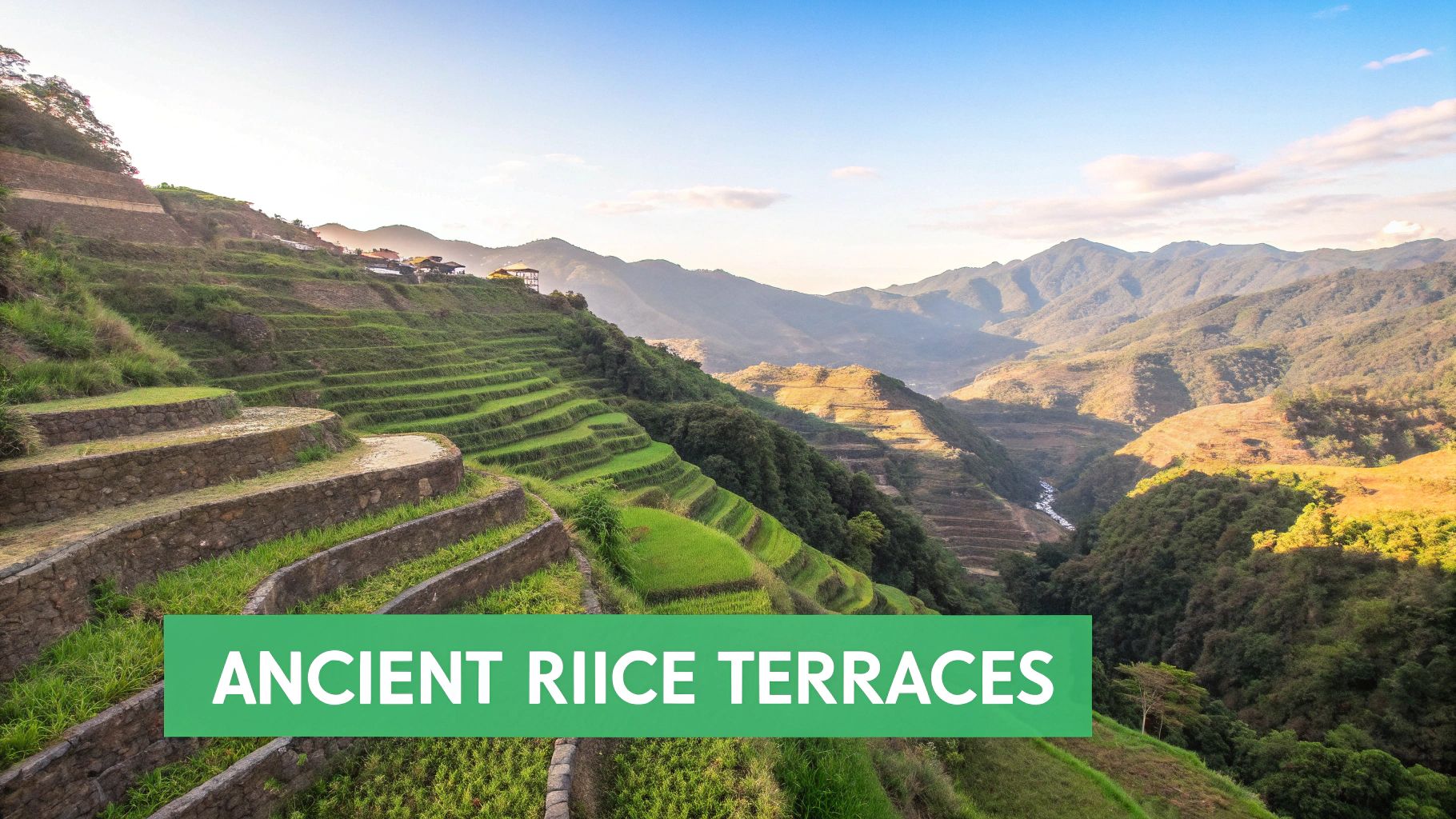
1. Banaue Rice Terraces: The Eighth Wonder of the World
Carved into the mountains of Ifugao by the ancestors of the indigenous Batad people, the Banaue Rice Terraces are a monumental feat of ancient engineering. Often called the "Eighth Wonder of the World," this breathtaking agricultural marvel is a testament to a community's deep connection to their land. It stands as one of the most iconic famous Philippine landmarks and is a designated UNESCO World Heritage site.
These terraces were built over 2,000 years ago, largely by hand with minimal equipment. They follow the natural contours of the mountains, creating a stunning stairway-like landscape that stretches for miles. An ancient, gravity-fed irrigation system diverts water from mountaintop rainforests to nourish the rice paddies below, a sustainable practice still in use today.
The site is a living cultural landscape, not just a historical relic. The local Ifugao communities continue to plant and harvest rice, preserving the traditions and knowledge passed down through generations. This harmonious relationship between humanity and nature is what makes the terraces a profoundly significant destination.
Visitor Information & Tips
- Location: Banaue, Ifugao Province, Cordillera Administrative Region (Coordinates: approx. 16.9246° N, 120.9575° E)
- Best Time to Visit: Visit between June and July for lush, vibrant green terraces or from March to May for the golden hues of harvest season.
- Getting There: The journey involves a long bus ride (9-12 hours) from Manila. It is advisable to book tickets in advance, especially during peak seasons.
- Travel Tip: Hire a local guide. Their expertise is invaluable for navigating the trails safely and for sharing the rich cultural history of the Ifugao people and their sacred land.
EarthChasers Mission: 'Guardian of the Grains'
Mission Brief: Document the ancient irrigation system that sustains the Banaue Rice Terraces. Players must photograph three key components of the water system: the source spring, a primary canal, and a distribution channel feeding a rice paddy. Earn bonus points for capturing a photo of a local farmer tending to the terraces, showcasing the site as a living landscape.
2. Banaue Rice Terraces: The Eighth Wonder of the World
Carved into the mountains of Ifugao by the ancestors of the indigenous Batad people, the Banaue Rice Terraces are a monumental feat of ancient engineering. Often called the "Eighth Wonder of the World," this breathtaking agricultural marvel is a testament to a community's deep connection to their land. It stands as one of the most iconic famous Philippine landmarks and is a designated UNESCO World Heritage site.
These terraces were built over 2,000 years ago, largely by hand with minimal equipment. They follow the natural contours of the mountains, creating a stunning stairway-like landscape that stretches for miles. The structure is an incredible example of modifying natural landscapes, showcasing a mastery of the area's complex topography on earthchasers.com. An ancient, gravity-fed irrigation system diverts water from mountaintop rainforests to nourish the rice paddies, a sustainable practice still in use today.
The site is a living cultural landscape, not just a historical relic. The local Ifugao communities continue to plant and harvest rice, preserving the traditions and knowledge passed down through generations. This harmonious relationship between humanity and nature is what makes the terraces a profoundly significant destination.
Visitor Information & Tips
- Location: Banaue, Ifugao Province, Cordillera Administrative Region (Coordinates: approx. 16.9246° N, 120.9575° E)
- Best Time to Visit: Visit between June and August for lush, vibrant green terraces or from March to May for the golden hues of harvest season.
- Getting There: The journey involves a long bus ride (9-12 hours) from Manila. It is advisable to book tickets in advance, especially during peak seasons.
- Travel Tip: Hire a local guide to safely navigate the steep terrain and understand Ifugao culture. Staying in a local homestay offers an authentic, immersive experience.
EarthChasers Mission: 'Guardian of the Grains'
Mission Brief: Document the ancient irrigation system that sustains the Banaue Rice Terraces. Players must photograph three key components of the water system: the source spring, a primary canal, and a distribution channel feeding a rice paddy. Earn bonus points for capturing a photo of a local farmer tending to the terraces, showcasing the site as a living landscape.
3. Intramuros: The Walled City of Manila
Step back in time within the historic heart of Manila, the walled city of Intramuros. Established in 1571 by the Spanish, this massive stone citadel served as the center of political, military, and religious power during the Spanish colonial period. Its formidable walls, defensive fortifications, and cobblestone streets make it one of the most significant famous Philippine landmarks, offering a tangible connection to over 300 years of history.
Within its 64-hectare expanse, Intramuros houses beautifully preserved Spanish colonial architecture, including centuries-old churches like the San Agustin Church, a UNESCO World Heritage site. The city was meticulously planned, with a grid-like street system, plazas, and courtyards that reflect European urban design. Despite heavy damage during World War II, extensive restoration efforts have revived its historic grandeur.
Today, Intramuros is a living museum, blending historical sites with modern life. It is home to universities, restaurants, and government offices, while horse-drawn carriages known as kalesas still travel its streets. This fusion of past and present ensures its relevance and provides a profound educational and cultural experience for all who visit.
Visitor Information & Tips
- Location: Intramuros District, Manila, National Capital Region (Coordinates: approx. 14.5895° N, 120.9745° E)
- Best Time to Visit: The dry season from December to May offers the best weather for walking tours. Visit early in the morning to avoid the midday heat and crowds.
- Getting There: Easily accessible via taxi, ride-sharing apps, or the LRT-1 (Central Terminal Station) from various points in Metro Manila.
- Travel Tip: Hire a licensed tour guide or join a walking tour to gain a comprehensive understanding of the rich history behind the walls, churches, and fortifications like Fort Santiago.
EarthChasers Mission: 'Colonial Chronicler'
Mission Brief: Capture the architectural legacy of Spanish colonial rule within Intramuros. Players must photograph three distinct architectural elements: the Baroque facade of San Agustin Church, a cannon emplacement at Fort Santiago overlooking the Pasig River, and a traditional kalesa on a cobblestone street. Earn bonus points for a photo taken inside the dungeons of Fort Santiago.
4. Taal Volcano and Crater Lake: A Geological Marvel
Taal Volcano presents one of the most picturesque and precarious sights in the country. This complex volcano is famous for its unique nested structure: an island within a lake, which is on an island within a larger lake. This "lake-in-a-volcano-in-a-lake-on-an-island" formation makes it a geological marvel and one of the most photographed famous Philippine landmarks. Located just a few hours from Manila, it remains one of the world's most active and closely monitored volcanoes.
Despite its history of powerful eruptions, Taal's beauty is undeniable. The main crater once held a vibrant, turquoise lake, creating a stunning contrast with the surrounding volcanic terrain. While recent activity has altered its appearance, the panoramic views from the ridges of Tagaytay still offer a breathtaking spectacle of the entire caldera. Its proximity to the capital and its volatile nature make it a compelling subject of both scientific study and tourism.
The volcano is a symbol of nature's dual capacity for serene beauty and immense power. Its ever-changing landscape serves as a constant reminder of the dynamic geological forces that shape our planet, securing its place as a must-see, albeit from a safe distance, destination.
Visitor Information & Tips
- Location: Batangas Province, CALABARZON Region (Coordinates: approx. 14.0113° N, 120.9970° E)
- Best Time to Visit: The dry season, from November to April, offers the clearest views. Always check the latest volcanic activity advisories from PHIVOLCS before planning a trip.
- Getting There: Tagaytay City, which offers the best viewing points, is a 2-3 hour drive from Manila. Various tour operators offer boat trips and hikes when conditions are deemed safe.
- Travel Tip: Start any planned hikes very early in the morning to avoid the intense midday heat. Wear proper hiking shoes, use strong sun protection, and carry an ample supply of water.
EarthChasers Mission: 'Ring of Fire'
Mission Brief: Capture the unique geological layers of Taal. Players must photograph the main volcano from a high vantage point in Tagaytay, then, if accessible, take a picture from a boat on Taal Lake looking towards the volcano. Earn bonus points for documenting any visible signs of volcanic activity, such as steam vents, as confirmed by official sources.
5. Chocolate Hills: Nature's Giant Kisses
Spread across the island of Bohol, the Chocolate Hills are an extraordinary geological formation that captivates all who see them. This unique landscape consists of at least 1,260 conical karst hills of nearly uniform shape, creating a rolling, almost surreal panorama. While covered in green grass for most of the year, they earn their delicious name during the dry season when the vegetation withers and turns a rich chocolate brown.
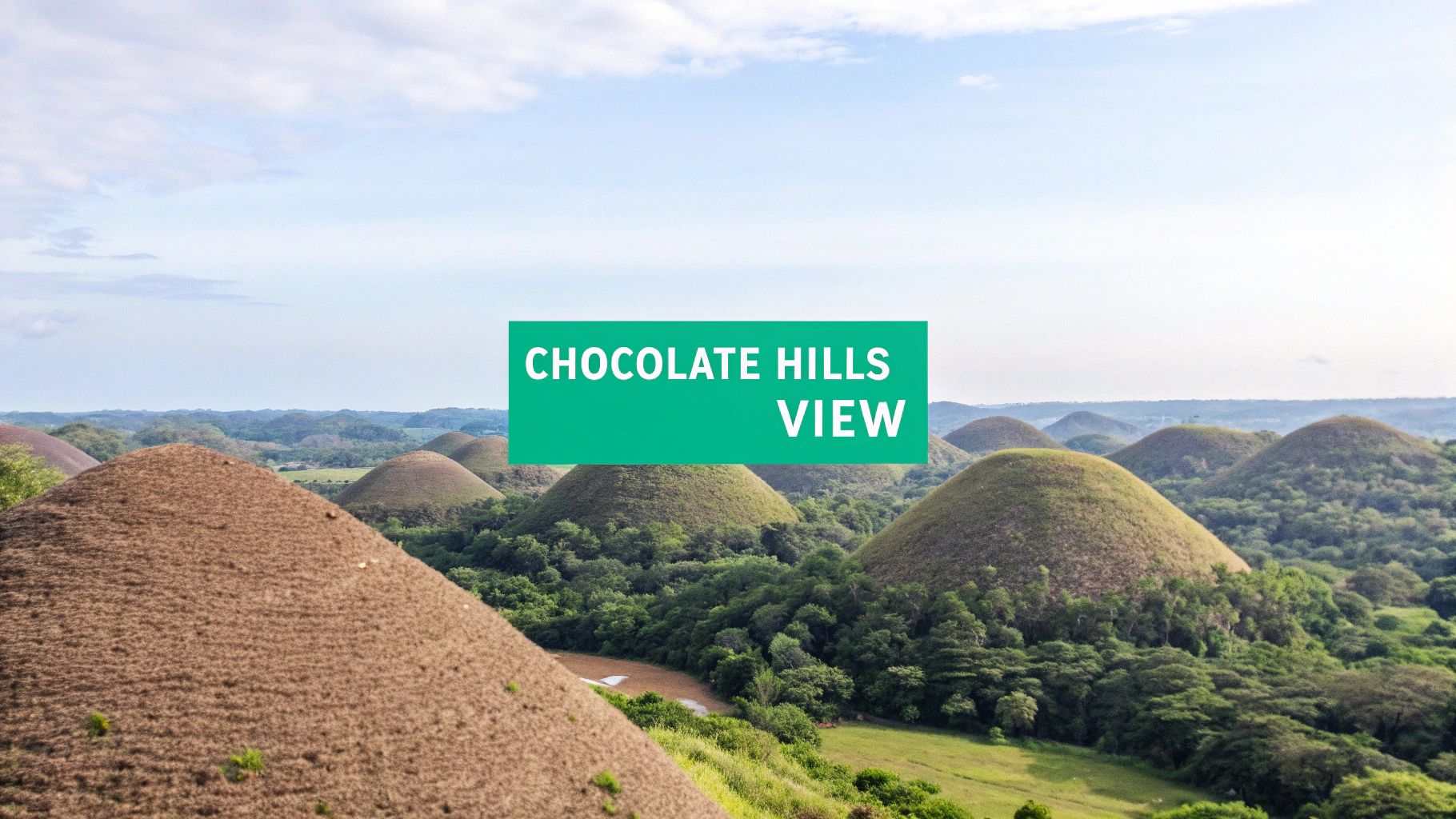
This geological oddity was formed from limestone deposits on the sea floor that were uplifted and then eroded by water over millennia. Legends, however, offer more romantic explanations, telling tales of fighting giants who hurled boulders at each other. Regardless of their origin, the hills are a core part of Bohol's identity and stand as one of the most mysterious and famous Philippine landmarks.
The otherworldly scenery makes the Chocolate Hills a must-visit destination, offering views that seem to be plucked from a fantasy novel. They are a powerful example of nature's artistry and the fascinating results of long-term geological processes.
Visitor Information & Tips
- Location: Carmen, Bohol Province, Central Visayas Region (Coordinates: approx. 9.8519° N, 124.1685° E)
- Best Time to Visit: To see the hills in their iconic "chocolate" state, visit during the dry season from late December to May. Early morning visits offer the best light for photography.
- Getting There: From Tagbilaran City, Bohol's capital, you can take a bus or van heading to Carmen. The main viewing complex is a popular stop.
- Travel Tip: Wear comfortable walking shoes for the climb up to the main viewpoint. Combine your trip with a visit to the nearby Tarsier Sanctuary to see another of Bohol's famous residents.
EarthChasers Mission: 'Cacao Conundrum'
Mission Brief: Capture the unique topography of the Chocolate Hills. Players must take a panoramic photo from the main viewing deck, a close-up shot of an individual hill's texture, and a picture showing the scale of the hills against a man-made object (like the viewing platform or a road). Earn bonus points for capturing the hills during sunrise or sunset, highlighting their dramatic shadows.
6. Mayon Volcano: The Perfect Cone
Rising majestically over the Bicol Region, Mayon Volcano is renowned worldwide for its near-perfect symmetrical cone, a breathtaking sight that has cemented its status as a national symbol. As the Philippines' most active volcano, its beauty is matched only by its raw power, making it a geological wonder and one of the most significant famous Philippine landmarks. Its frequent, often dramatic, eruptions have shaped the surrounding landscape and the lives of the local communities.
This iconic stratovolcano stands as a central figure in local folklore, most notably in the tragic love story of the princess Magayon, from whom its name is derived. Despite the constant threat of eruption, the fertile volcanic soil supports a thriving agricultural community at its base. The volcano and its surrounding area form the Mayon Volcano Natural Park, a protected landscape aimed at conserving its unique biodiversity.
Mayon’s blend of sublime beauty and geological volatility makes it a compelling destination for adventurers and nature lovers alike. It offers a stark reminder of the dynamic forces that shape our planet, standing as a living monument to both nature’s creative and destructive power.
Visitor Information & Tips
- Location: Albay Province, Bicol Region (Coordinates: approx. 13.2562° N, 123.6859° E)
- Best Time to Visit: The dry season from March to May offers the clearest views. Always check the official PHIVOLCS volcanic alert status before planning any activity.
- Getting There: Fly into Legazpi City, which serves as the main gateway. The volcano is visible from almost anywhere in the city.
- Travel Tip: For your safety, always hire an accredited local guide for any trekking activities. The terrain is challenging, and conditions can change rapidly. Wear proper hiking boots as the volcanic soil and scree are sharp.
EarthChasers Mission: 'Ring of Fire'
Mission Brief: Capture the duality of Mayon Volcano’s beauty and power. Players must photograph the volcano's perfect cone from the Cagsawa Ruins, document a field of old lava rock, and find an example of local flora thriving on the volcanic soil. Earn bonus points for a clear, unobstructed shot of the summit at sunrise or sunset.
7. Palawan Underground River: A Subterranean Spectacle
Officially known as the Puerto Princesa Subterranean River National Park, this natural wonder is a breathtaking journey into the earth's depths. The site features an 8.2-kilometer navigable underground river that flows directly into the sea, a globally unique phenomenon. As one of the most celebrated famous Philippine landmarks, it is recognized as a UNESCO World Heritage Site and one of the New 7 Wonders of Nature.
Visitors glide on paddle boats through a spectacular limestone karst cave system, witnessing stunning stalactite and stalagmite formations that have formed over millions of years. The main chamber, known as the "Cathedral," boasts ceilings soaring over 60 meters high and awe-inspiring rock formations resembling religious icons, animals, and vegetables.
This park is more than just a cave; it is a complete mountain-to-sea ecosystem that protects a significant Asian forest. The area is a sanctuary for diverse wildlife, including monitor lizards, monkeys, and hundreds of bird species, making it a crucial conservation site.
Embedded content
Visitor Information & Tips
- Location: Puerto Princesa, Palawan Province, Mimaropa Region (Coordinates: approx. 10.1997° N, 118.9263° E)
- Best Time to Visit: The dry season, from November to May, offers calmer waters and more favorable conditions for boat tours.
- Getting There: Fly into Puerto Princesa International Airport (PPS). From the city, it’s a 1.5 to 2-hour land journey to Sabang, the river's entry point.
- Travel Tip: Book your tour and secure your permit well in advance, as daily visitor numbers are limited to protect the fragile ecosystem. Arrive early to avoid the midday crowds.
EarthChasers Mission: 'Echoes of the Deep'
Mission Brief: Document the unique geological and biological features of the subterranean river. Players must capture images of three distinct rock formations inside the cave, a swiftlet or bat colony on the cave ceiling, and the point where the river emerges into the sea. Earn bonus points for a clear photo of the "Cathedral" chamber.
8. Boracay Island - White Beach
Celebrated worldwide for its almost impossibly fine, powdery white sand and stunning turquoise waters, Boracay's White Beach is the quintessential tropical paradise. This four-kilometer stretch of coastline is not just a beach; it's a global destination that has consistently ranked among the best in the world. It has become one of the most recognized famous Philippine landmarks, drawing visitors who seek both relaxation and adventure.

The beach is segmented into three "stations," each offering a different atmosphere. Station 1 boasts luxury resorts and the finest sand, Station 2 is the vibrant commercial and dining hub, and Station 3 offers a more laid-back, budget-friendly vibe. After a significant environmental rehabilitation, Boracay has re-emerged with a renewed focus on sustainability, balancing its natural allure with modern tourism.
The island's appeal lies in its versatility. Mornings are perfect for swimming and water sports in the calm sea, afternoons are for lounging under palm trees, and evenings come alive with spectacular sunsets and a dynamic social scene. This blend of natural beauty and vibrant energy solidifies its place as a must-visit landmark.
Visitor Information & Tips
- Location: Boracay Island, Malay, Aklan Province, Western Visayas (Coordinates: approx. 11.9725° N, 121.9211° E)
- Best Time to Visit: The dry season from November to April offers the best weather. Visit during the shoulder months (April-May) for a good balance of sun and fewer crowds.
- Getting There: Fly to Caticlan Airport (MPH), the nearest gateway. From there, it's a short tricycle ride to the jetty port and a 15-minute ferry ride to the island.
- Travel Tip: Enjoy the world-famous sunset from the water by booking a "paraw" sailing trip. These traditional outrigger boats provide a serene and unforgettable viewing experience.
EarthChasers Mission: 'Sands of Time'
Mission Brief: Capture the unique character of White Beach's three stations. Players must photograph a luxury resort facade in Station 1, a bustling restaurant scene in Station 2, and a quiet, relaxed beachfront in Station 3. Earn bonus points for a panoramic shot of the sunset that includes a traditional paraw sailboat on the horizon.
9. Hinulugang Taktak & Philippine Bamboo Groves: Rizal's Natural Retreat
Nestled in Antipolo, Rizal, the Hinulugang Taktak National Park offers a refreshing natural escape just a short drive from the bustling Metro Manila. Famous for its cascading waterfall, this protected landscape has been a popular local destination for generations. Recent rehabilitation efforts have revitalized the area, adding attractions like a serene bamboo grove, spiderweb viewing deck, and swimming pools, making it one of the most accessible famous Philippine landmarks for a quick nature trip.
The park’s centerpiece is the 21-meter high Hinulugang Taktak falls, whose name, according to legend, originated from a large bell (taktak) that was dropped (hinulog) into its waters. Beyond the falls, the adjacent bamboo groves provide a tranquil atmosphere with their tall, swaying stalks that create a cool, shaded canopy. This combination of a historic waterfall and serene bamboo trails offers a multifaceted natural experience.
Serving as a green lung for the region, the park underscores the importance of conserving urban natural spaces. It stands as a testament to successful environmental rehabilitation, transforming a once-neglected spot into a clean, family-friendly destination where visitors can reconnect with nature without venturing far from the city.
Visitor Information & Tips
- Location: Antipolo, Rizal Province, Calabarzon Region (Coordinates: approx. 14.6069° N, 121.1736° E)
- Best Time to Visit: The falls are most impressive during the rainy season (June to November), but the park is pleasant year-round. Visit on a weekday morning to avoid crowds.
- Getting There: Easily accessible from Metro Manila via public transport (jeepney, UV Express) or private vehicle. The drive typically takes 1-2 hours depending on traffic.
- Travel Tip: Wear sturdy, non-slip footwear as paths near the waterfall can be slippery. Bring a change of clothes and a towel if you plan to use the swimming facilities.
EarthChasers Mission: 'Rizal's Echoing Falls'
Mission Brief: Capture the rejuvenated spirit of Hinulugang Taktak. Your task is to photograph the main waterfall from the primary viewing deck, find and document a unique spiderweb-like art installation within the park, and take a serene shot from inside the bamboo grove. Earn bonus points for a photo showing recreational activities like swimming or picnicking, highlighting the park's community role.
10. Tubbataha Reefs National Marine Park: A Jewel of the Sulu Sea
Located in the heart of the Sulu Sea, the Tubbataha Reefs Natural Park is a marine and bird sanctuary of global significance. This protected area consists of two large coral atolls, North Atoll and South Atoll, and the smaller Jessie Beazley Reef. As a UNESCO World Heritage site, it is recognized for its pristine coral reefs and staggering biodiversity, making it one of the most sought-after famous Philippine landmarks for divers and conservationists alike.
The park is a spectacular example of a reef with a very high density of marine species. Its isolated location protects it from over-exploitation, allowing marine life to flourish. Visitors will find over 600 species of fish, 360 species of corals, 11 species of sharks, and 13 species of dolphins and whales. The atolls serve as a critical nesting ground for seabirds and marine turtles, showcasing a vibrant, interconnected ecosystem.
Tubbataha is not just a destination; it's a vital center for marine science and a model for marine conservation worldwide. Its protected status ensures the replenishment of fish stocks in the wider Sulu-Sulawesi region, highlighting its crucial role in the health of our oceans. Access is strictly regulated to preserve its fragile environment for future generations.
Visitor Information & Tips
- Location: In the middle of the Sulu Sea, about 150 km southeast of Puerto Princesa City, Palawan (Coordinates: approx. 8.9517° N, 119.9075° E)
- Best Time to Visit: The dive season is very short, running from mid-March to mid-June when the seas are calmest and visibility is at its peak.
- Getting There: Access is exclusively via liveaboard boats from Puerto Princesa, Palawan. The journey takes approximately 10-12 hours.
- Travel Tip: Book your liveaboard trip at least a year in advance, as slots are extremely limited. Ensure you have an Advanced Open Water Diver certification, as currents can be strong.
EarthChasers Mission: 'Sulu Sea Sentinel'
Mission Brief: Document the incredible biodiversity of Tubbataha Reefs. Players must photograph a sea turtle, a school of jackfish, and a whitetip reef shark in their natural habitat. Earn bonus points for capturing an image of a vibrant coral wall, showcasing the health and density of the reef ecosystem.
11. Vigan Historic City (Casco Viejo de Vigan)
Stepping onto the cobblestone streets of Vigan is like traveling back to the 16th-century Spanish colonial period. As one of the best-preserved Hispanic towns in Asia, its historic center, or Casco Viejo, showcases a unique fusion of Filipino, Chinese, and European architectural and cultural influences. This living museum stands as one of the most distinctive famous Philippine landmarks and is recognized as a UNESCO World Heritage site.
Vigan’s architecture is its most captivating feature, with ancestral stone houses (Bahay na Bato) lining the streets, characterized by their massive hardwood foundations, red-tiled roofs, and capiz shell windows. The city's grid-like street plan, a classic Spanish colonial design, remains intact, creating a beautifully preserved urban landscape that has survived the test of time.
Unlike many historical sites, Vigan is a vibrant, breathing city where a unique Mestizo culture thrives. The clatter of horse-drawn carriages, or kalesas, echoes through the streets, and local artisans continue to practice traditional crafts like pottery (pagburnayan) and loom weaving (inabel), making Vigan a truly immersive cultural destination. Learn more about its heritage by exploring this list of World Heritage sites.
Visitor Information & Tips
- Location: Vigan City, Ilocos Sur Province, Ilocos Region (Coordinates: approx. 17.5744° N, 120.3871° E)
- Best Time to Visit: Travel during the dry season from November to April to comfortably explore the city on foot or by kalesa.
- Getting There: Vigan is accessible via a long-distance bus from Manila (8-10 hours) or by flying into the nearby Laoag International Airport and taking a bus or van.
- Travel Tip: Explore Calle Crisologo during the late afternoon. The "golden hour" light beautifully illuminates the heritage houses, creating stunning photo opportunities.
EarthChasers Mission: 'Colonial Chronicler'
Mission Brief: Capture the architectural soul of Vigan's colonial era. Players must photograph three distinct architectural elements: a capiz shell window, the cobblestones of Calle Crisologo, and the facade of an ancestral Bahay na Bato. Earn bonus points for a video recording the sound of a kalesa traveling down the historic street.
12. Mount Pinatubo: A Landscape Reborn from Ash
Once the site of the second-largest volcanic eruption of the 20th century, Mount Pinatubo is a powerful symbol of nature's destructive and regenerative force. Its catastrophic 1991 eruption altered global climate patterns and radically reshaped the surrounding landscape. Today, this geological titan has transformed into a premier destination for adventure tourism and is considered one of the most unique famous Philippine landmarks.
Where there was once devastation, a stunning turquoise crater lake now rests peacefully, surrounded by the stark, beautiful lahar-canyon walls carved by subsequent rains. The journey to the crater is an adventure in itself, involving a thrilling 4x4 ride across a vast, moon-like ash field and a trek through volcanic streams and rock formations. This dramatic landscape offers a living lesson in geology and ecological recovery. The tectonic activity that led to its formation is a fascinating study of Earth's powerful forces. Learn more about the science behind volcanoes on earthchasers.com.
The site serves as a poignant reminder of nature's duality. It’s a place where visitors can witness firsthand the incredible process of an ecosystem healing itself, creating a breathtaking and unforgettable destination from a place of immense geological power.
Visitor Information & Tips
- Location: Borders of Zambales, Tarlac, and Pampanga provinces, Central Luzon (Coordinates: approx. 15.1425° N, 120.3500° E)
- Best Time to Visit: The dry season, from November to April, is the only safe time for trekking. The trails are closed during the rainy season due to the risk of flash floods and landslides.
- Getting There: The most common jump-off point is Sta. Juliana in Capas, Tarlac, where 4x4 rentals and tour operators are based. This is about a 2-3 hour drive from Manila.
- Travel Tip: Start your hike as early as possible (around 6 AM) to avoid the intense midday sun. Bring at least 2-3 liters of water per person, as the trail offers little shade. Sturdy hiking boots are essential for the rocky, uneven terrain.
EarthChasers Mission: 'Crater Lake Chronometer'
Mission Brief: Capture the geological transformation of Mount Pinatubo. Players must photograph the expansive lahar (volcanic ash) field from the 4x4, a natural stream cutting through the canyon, and the iconic view of the crater lake from the summit viewpoint. Earn bonus points by including another player in the summit photo to document the scale of the caldera.
12 Famous Philippine Landmarks Comparison
| Site | Visitation complexity 🔄 | Resource requirements ⚡ | Expected outcomes 📊 | Ideal use cases 💡 | Key advantages ⭐ |
|---|---|---|---|---|---|
| Borobudur Temple (Candi Borobudur) | Moderate — stair climbs, large crowds | Moderate — entrance fee, half-day to full day, guide recommended | Deep architectural & religious insight; panoramic temple views | Heritage tourism, Buddhist studies, photography | ⭐ Major Buddhist monument; extensive reliefs and pilgrimage value |
| Banaue Rice Terraces | Moderate — remote access, steep trails | Low–Moderate — time, transport, local guide, overnight stays | Immersive cultural landscape; scenic terraces | Cultural immersion, ethnography, landscape photography | ⭐ Ancient hand-built engineering; living UNESCO landscape |
| Intramuros (Walled City of Manila) | Low — central, walkable historic district | Low — minimal fees, optional guided tours | Concentrated colonial history and museums | Day trips, history tours, accessible urban heritage | ⭐ Well-preserved colonial architecture, multiple museums |
| Taal Volcano and Crater Lake | Moderate — boat + hike; activity-related restrictions | Moderate — guide, checks for alerts, basic safety gear | Dramatic nested-crater views; geological learning | Geology enthusiasts, panoramic photography, short hikes | ⭐ Unique crater-within-lake formation; close to Manila |
| Chocolate Hills | Low — roadside viewpoints, short walks | Low — easy access, short visit time | Distinctive karst vistas; strong photo opportunities | Scenic viewing, family day trips, quick stops | ⭐ Unusual uniform karst hills; easy accessibility |
| Mayon Volcano | Moderate–High — challenging climbs, active volcano risks | High — experienced guides, permits, fitness and safety prep | Iconic volcanic vistas; advanced hiking challenge | Experienced hikers, volcano observers, adventure tourism | ⭐ Nearly perfect cone; strong cultural and scenic symbol |
| Palawan Underground River | Moderate — boat access, guided underground tour, visitor caps | Moderate–High — advance booking, permit limits, transport costs | Spectacular cave chambers; conservation-focused experience | Eco-tourism, cave enthusiasts, conservation education | ⭐ UNESCO site with spectacular caverns and unique ecosystem |
| Boracay Island - White Beach | Low — highly accessible with extensive infrastructure | Variable — budget to luxury options; can be expensive at peak | Beach leisure, water sports, vibrant nightlife | Beach holidays, water-sport activities, nightlife tourism | ⭐ World-class white sand and well-developed amenities |
| Sagano Bamboo Groves / Hinulugang Taktak | Low — short drive from Manila, easy trails and pools | Low — affordable entry, day-trip friendly | Tranquil nature walks; waterfall swimming (seasonal) | Day trips, family outings, nature relaxation | ⭐ Proximity to Metro Manila; scenic waterfalls and bamboo groves |
| Tubbataha Reefs National Marine Park | High — liveaboard logistics, seasonal access window | Very high — advanced dive certification, costly liveaboards, months-ahead booking | Exceptional marine biodiversity and advanced diving experiences | Advanced divers, marine researchers, conservation-focused trips | ⭐ Pristine UNESCO marine sanctuary with world-class reefs |
| Vigan Historic City (Casco Viejo de Vigan) | Low — walkable historic core, pedestrian-friendly | Low — affordable stays, guided kalesa tours available | Authentic colonial-era streetscape and cultural insights | Heritage tourism, cultural immersion, culinary exploration | ⭐ Exceptionally preserved Spanish colonial town; UNESCO site |
| Mount Pinatubo | Moderate — 4WD access + trek, dry-season only | Moderate — guide/transport arrangements, seasonal constraints | Post-eruption crater lake views; educational volcanology site | Adventure tourists, geology students, day-adventure trips | ⭐ Iconic 1991 eruption site with striking crater lake landscape |
Your Adventure Awaits: From Virtual Exploration to Real-World Discovery
Our journey across the Philippine archipelago has revealed a stunning collection of natural wonders, historical treasures, and cultural cornerstones. From the ancient, hand-carved steps of the Banaue Rice Terraces to the fiery, perfect cone of Mayon Volcano, the landmarks we've explored are far more than just points on a map. They are the living, breathing soul of the nation, each telling a unique story of resilience, artistry, and geological grandeur. This guide has aimed to be more than a simple list; it is an invitation to engage with these sites on a deeper level, whether from your screen or on the ground.
The sheer diversity among these famous Philippine landmarks is a testament to the country's multifaceted identity. You can witness the colonial echoes within the cobblestone streets of Vigan's Historic City, then dive into the pristine, underwater Eden of Tubbataha Reefs. You can feel the powerful history of revolution and resilience within the ancient walls of Intramuros and then marvel at the catastrophic beauty of Mount Pinatubo's crater lake, a landscape reborn from destruction. Each location offers a distinct lens through which to view the Philippines' past, present, and future.
Bridging the Virtual and the Real
One of the most powerful takeaways from this roundup is the synergy between virtual preparation and real-world adventure. By using a platform like EarthChasers, you are not just previewing a destination; you are building a foundational understanding that will enrich your physical travel immeasurably.
- Gain True Perspective: Completing an EarthChasers mission to digitally circumnavigate the Chocolate Hills or fly over the vast expanse of the Palawan Underground River's park provides a sense of scale that photos alone cannot convey.
- Contextualize Your Journey: Tracing the historic walls of Intramuros or virtually navigating the intricate paths of the Banaue Rice Terraces helps you appreciate the layout and strategic importance of these sites before you even set foot there.
- Inspire Your Itinerary: Discovering the unique topography of Taal Volcano or the sprawling coral systems of Tubbataha Reefs can help you prioritize what you want to see and do, turning a vague interest into a concrete travel plan.
This digital-first approach transforms you from a passive tourist into an informed explorer, ready to engage with each landmark's story with newfound appreciation.
Your Next Steps: From Planning to Packing
The adventure truly begins now. The first step is to turn your inspiration into a tangible plan. Revisit the landmarks that captured your imagination the most. Is it the geological mystery of the Chocolate Hills, the historical depth of Vigan, or the adrenaline of trekking a volcano? Use the visitor tips and EarthChasers mission ideas in this article to start building a personalized itinerary that aligns with your interests as a geography enthusiast, gamer, and trivia buff.
As you move from planning your route to preparing for the trip itself, remember that efficient packing is crucial for a smooth journey. Navigating multiple islands, climates, and activities requires smart preparation. For a comprehensive guide on what to bring and how to organize it for a multi-destination trip, consulting some expert international packing tips can make all the difference, ensuring you’re ready for everything from a city tour in Manila to a beach day in Boracay.
Ultimately, these famous Philippine landmarks are waiting to be experienced. They are vibrant, dynamic places that offer profound connections to nature, history, and culture. Mastering the art of combining digital exploration with physical travel doesn't just make for a better vacation; it fosters a deeper, more meaningful understanding of our world. The Philippines offers a spectacular classroom, and your expedition, whether virtual or real, has just begun.
Ready to start your virtual reconnaissance? Download EarthChasers today and begin exploring these incredible Philippine landmarks from a stunning new perspective. Plan your real-world adventure with the ultimate digital co-pilot at EarthChasers and turn your travel dreams into your next great discovery.