What Is Relief in Geography a Guide to Earths Terrain
Understand what is relief in geography with our clear guide. We explore how mountains, plains, and valleys shape climate, ecosystems, and human society.
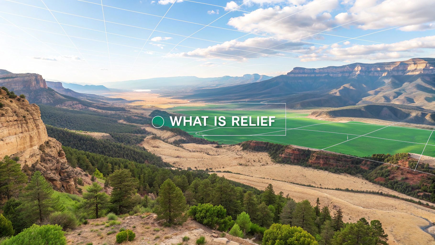
In geography, relief is a simple but powerful idea: it’s the shape of the land. Think of it as the planet’s texture—all the bumps and grooves that make up its surface. It's the grand difference between the highest peak of a mountain range and the deepest point of a valley, giving us a true three-dimensional picture of any landscape.
Decoding Earth's Textured Surface
If you were to run your hand over a globe, you wouldn't just feel a perfectly smooth ball. You’d feel the jagged edges of mountain ranges, the gentle depressions of valleys, and the vast, flat stretches of plains. That texture is exactly what relief is all about.
Essentially, relief is the story of the Earth’s surface told through its highs and lows. It covers everything from sprawling flatlands and towering mountains to the deepest trenches hidden beneath the ocean. While relief describes the "what" (the shape), it's closely related to another key concept, topography, which focuses on the "where" (the detailed mapping of that shape). You can learn more about this in our guide to what topography is in geography.
The Three Pillars of Relief
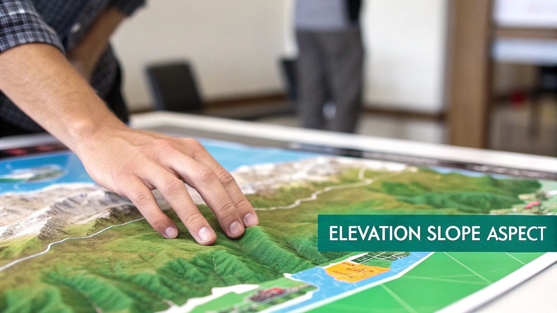
To really get a handle on any landscape, geographers break down relief into three fundamental building blocks. These components work together to define the land's form and how it behaves.
Let's take a quick look at the fundamental elements geographers use to describe the shape of the land.
The Core Components of Geographic Relief
| Component | What It Measures | Real-World Example |
|---|---|---|
| Elevation | The height of a point above a reference, usually sea level. | Mount Everest has an elevation of 29,032 feet, while the Dead Sea shore sits at -1,412 feet. |
| Slope | The steepness or gradient of the land's surface. | A sheer cliff face has a nearly vertical slope, while the Great Plains have a very gentle, almost flat slope. |
| Aspect | The direction a slope faces (e.g., north-facing or south-facing). | In the Northern Hemisphere, a south-facing slope gets more sun, making it warmer and drier than a shady north-facing slope. |
These three pillars—elevation, slope, and aspect—are the language we use to describe and understand any terrain on the planet.
By analyzing these three components, geographers can read the landscape like a book, understanding not just its shape but also how it influences everything from climate to human settlement patterns.
It's the combination of these elements that creates the endless variety of landscapes we see across the globe, from the gentle, rolling hills of the English countryside to the dramatic, jagged peaks of the Andes.
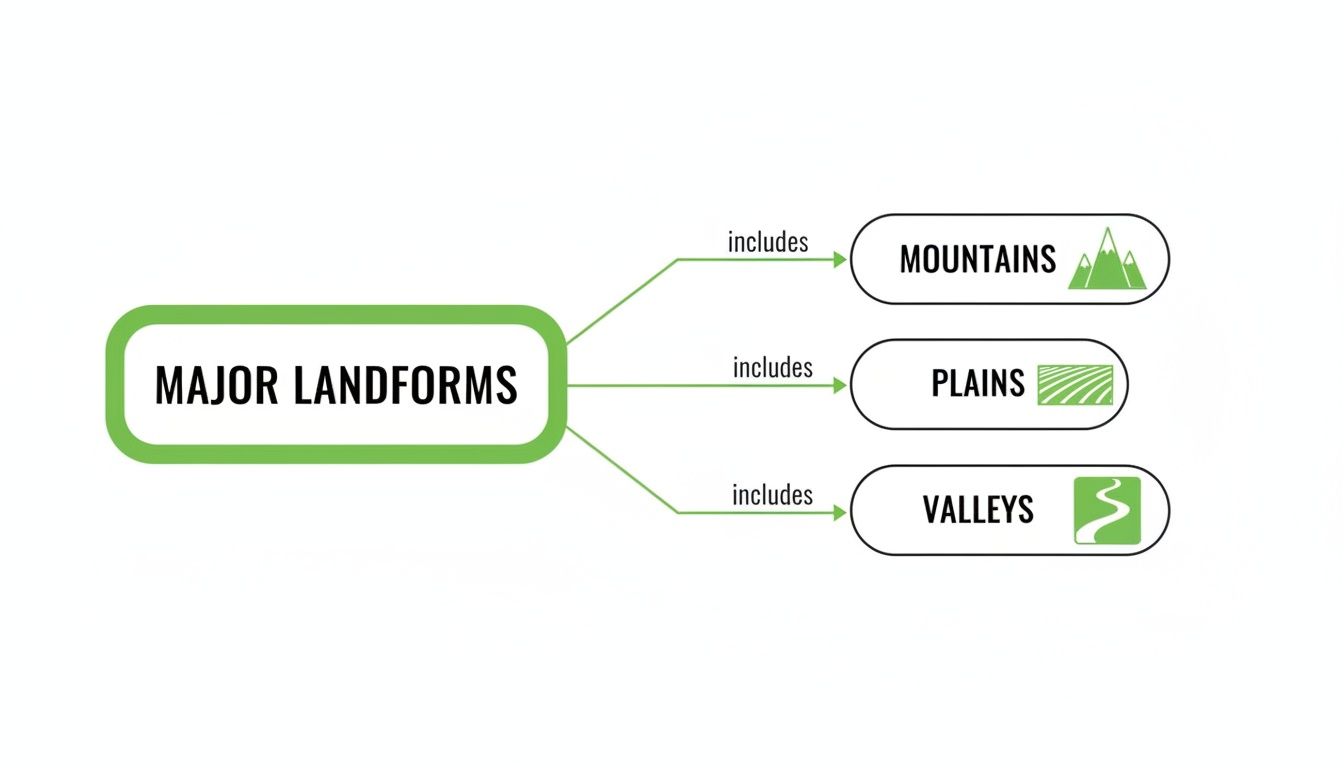
Exploring Earth’s Major Landforms
Now that we have a feel for the building blocks of relief, we can zoom out and appreciate the incredible structures they create across the globe. Geographic relief isn’t just a concept on a map—it’s the tangible, breathtaking landforms that define entire regions. Think of these features as the grand stages where Earth's geological drama plays out.
This tour will walk you through four of the planet's primary landforms, each sculpted by its own unique set of forces. We'll explore how these different expressions of relief shape the world we see, from towering, jagged peaks to vast, open horizons.
Mountains: Majestic and Mighty
Mountains are probably the most dramatic example of high relief. They’re the huge, natural elevations that shoot up abruptly from the surrounding landscape. A true mountain typically has steep slopes, a well-defined peak, and a whole lot of local relief.
Their creation is a story of immense power. Most of the world's great mountain ranges, like the Himalayas and the Andes, were forged by the colossal collision of tectonic plates. As these massive slabs of crust grind against each other, the land buckles and is shoved skyward, creating the peaks we see today. To get a better handle on these planetary forces, you can learn more about what tectonic plates are and how they continuously reshape our world.
Plateaus: The Elevated Plains
Plateaus are another type of high relief, but they have a key difference from mountains: their tops are incredibly flat. Picture a mountain that’s had its peak neatly sliced off, leaving a huge, elevated tableland—that’s a plateau. The Tibetan Plateau, often called the "Roof of the World," is the highest and largest on Earth, with an average elevation of over 14,800 feet.
These massive features can form in a few ways:
- Volcanic Activity: Repeated lava flows can spread out over vast areas, building up layers to create enormous plateaus like the Columbia Plateau in the United States.
- Uplift and Erosion: Tectonic forces can hoist up a large, flat block of rock. Over millions of years, rivers then carve deep canyons into the surface, leaving the high, flat areas standing, which is exactly how the Colorado Plateau was formed.
Plains: The Expansive Lowlands
In stark contrast to mountains and plateaus, plains are all about low relief. These are broad, sweeping areas of relatively flat land with very little change in elevation. While they might not have the drama of a mountain peak, plains are absolutely vital, covering more than one-third of the world's land area.
Plains are the agricultural heartlands of our planet. Their flat terrain and often fertile soils, laid down by rivers or glaciers, make them perfect for farming and building cities. The Great Plains of North America and the North European Plain are perfect examples.
Their formation is usually a story of deposition. Rivers carry silt and sediment downstream, depositing it over wide floodplains. In other places, ancient glaciers scraped the land flat, leaving behind layers of rock and soil when they melted.
Valleys: The Carved Troughs
Valleys are simply the low areas between hills or mountains, almost always with a river or stream running through them. They are fundamental to any landscape, acting as natural drainage channels. The shape of a valley often tells you exactly how it was made.
- V-Shaped Valleys: These are carved by the relentless power of rivers. Fast-flowing water cuts down into the rock, creating steep, V-shaped sides. The Grand Canyon is perhaps the most epic example of a river-carved valley on Earth.
- U-Shaped Valleys: These are the handiwork of massive glaciers. As a glacier grinds its way forward, it plucks and scrapes away the land, carving out a wide, flat-bottomed valley with steep sides. The result is a classic "U" shape, and Yosemite Valley in California is a textbook example of this glacial power.
How We Map and Measure Terrain
One of the biggest puzzles in geography has always been how to squash a complex, three-dimensional landscape onto a flat, two-dimensional map without losing its essential character. It's a tough challenge, but geographers have come up with some brilliant ways to translate raw elevation data into maps that give us a powerful feel for the terrain.
To truly understand and measure relief, we have to rely on good maps. For example, creating and using detailed maps of diverse terrain, like the ones for Glacier National Park, is vital for everything from scientific research to planning a weekend hike. These tools literally allow us to see the world in new ways.
The Classic Contour Map
The old-school hero of terrain mapping is the topographic map, which uses contour lines to show elevation. The best way to think about these lines is to imagine taking horizontal slices out of a mountain at perfectly regular intervals. Each line connects points that are at the exact same elevation, painting a surprisingly clear picture of the landscape's shape.
It's a simple but effective system:
- Lines packed tightly together? That means a steep slope—get ready for a tough climb.
- Lines spaced far apart? You're looking at a gentle slope or a flat area.
- A series of concentric circles? That’s a hill or a mountain peak.
From towering mountains to sweeping plains, each landform has a unique signature on a contour map, requiring different scales and techniques to capture its specific relief.
The Digital Revolution in Mapping
These days, mapping has gone digital with Digital Elevation Models (DEMs). A DEM is essentially a 3D computer model of a terrain's surface, usually built from data gathered by satellites or aircraft. This is the magic behind the immersive landscapes you see in Google Earth, the complex models used for climate simulations, and even the worlds you explore in video games.
These models are grids where every single point has an elevation value stored, allowing us to generate stunningly detailed visuals. Global datasets now make high-resolution DEMs accessible for anyone doing geospatial analysis anywhere in the world.
DEMs do more than just make pretty pictures; they turn abstract numbers into powerful insights. Geographers use them to calculate the exact angle of a slope, simulate how water might flow during a flood, or even pinpoint the best locations for wind turbines.
This digital approach gives us an incredible level of detail. For example, some global relief datasets offer resolutions ranging from a broad 37 km view all the way down to a super-fine 1 arc-second—a dataset so detailed it takes up 41 GB of space. By turning raw data into interactive models, we can explore and understand our planet’s terrain in ways that were unimaginable just a few decades ago.
How Relief Shapes Our Climate and Ecosystems
The shape of the land isn't just a static backdrop for life—it’s an active force that carves out our world's climates and ecosystems. Relief is the invisible hand that tells the wind where to blow, directs rivers where to flow, and ultimately decides where life can truly thrive. This connection between terrain and environment is one of the most powerful relationships in physical geography.
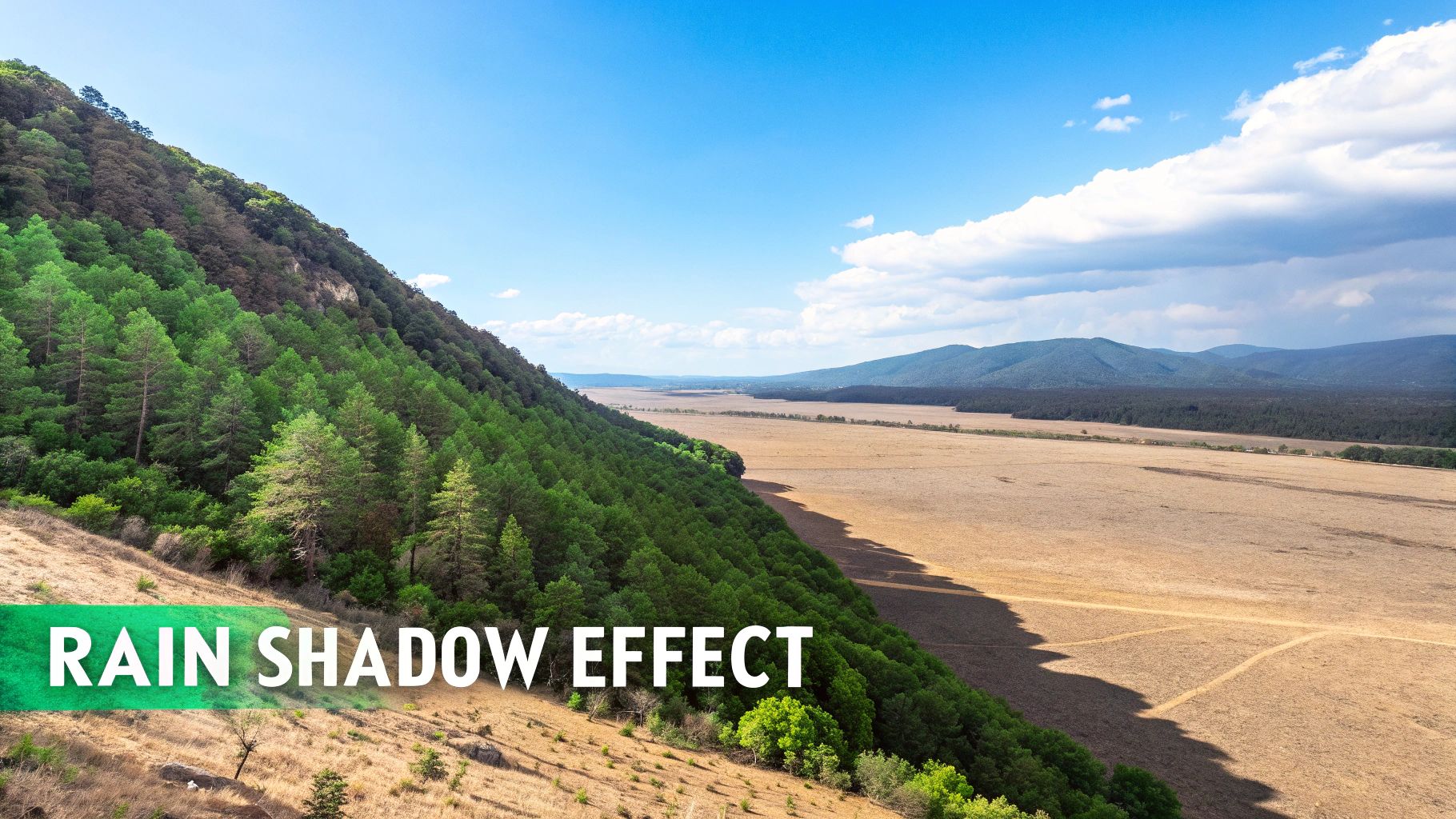
One of the most dramatic examples of relief at work is the rain shadow effect. It all starts when a mountain range gets in the way of moist, prevailing winds. As that air is forced to climb the mountains, it cools, and its water vapor condenses, falling as rain or snow on the "windward" side.
But what happens when that air finally makes it over the peak? It has already dumped most of its moisture, so as it descends on the other side, it's dry and warm. This creates a much drier, often desert-like climate on the "leeward" side, which is said to be in the mountain's "rain shadow."
From Lush Forests to Barren Deserts
For a textbook example, look no further than California’s Sierra Nevada mountain range. Moist winds roll in from the Pacific Ocean and are shoved upward by the towering peaks. This process drenches the western slopes, creating the perfect conditions for the lush, green forests that blanket the mountainside.
Once that air crosses the crest and tumbles down into the Great Basin, it’s a different story. It’s now dry, creating the arid desert landscapes of Nevada. The relief of the Sierras is directly responsible for these two completely different worlds sitting side-by-side.
This stark division highlights a core principle: relief doesn't just influence climate; it actively creates distinct climatic zones over very short distances. A mountain range acts as a massive wall, separating environments as effectively as an ocean.
A Journey Through Climate Zones
Relief also shapes ecosystems through simple altitude. Climbing a tall mountain is like taking a rapid journey through different climate zones. As you gain elevation, the temperature drops and the air thins, creating distinct bands of life called altitudinal zonation.
- Foothills: At the base, you’ll find forests or grasslands common to the surrounding lowlands.
- Montane Zone: A little higher up, the familiar deciduous trees give way to hardier conifers like pines and firs.
- Alpine Zone: Keep climbing past the treeline, and you'll hit a zone where trees can't survive. Here, the landscape is dominated by small shrubs, grasses, and tough alpine flowers.
- Nival Zone: At the very top, you reach a world of permanent snow and ice, where very little can live.
Each of these zones supports a unique community of plants and animals that have adapted to its specific conditions. It’s a perfect illustration of how the vertical dimension of relief creates a vibrant, layered tapestry of life, making mountains incredible hotspots for biodiversity.
The Human Story Written on the Landscape
The physical shape of the land is far more than just a backdrop for human events; it's an active character in our story. From our earliest farming settlements to the sprawling layouts of modern cities, the Earth's contours have always steered where and how civilizations take root.
Think about the world’s first great societies. It’s no coincidence that ancient Egypt and Mesopotamia blossomed in low, flat river valleys. The Nile River Valley, with its predictable floods and rich soil, offered the perfect low-relief landscape for agriculture, allowing populations to explode. These areas were simple to farm, easy to irrigate, and straightforward to build on—natural cradles of civilization.
But rugged, high-relief terrain like mountain ranges? They played a completely different role.
Fortresses and Frontiers
Historically, mountains have served as natural barriers and incredible defenses. The towering Himalayas acted as a massive wall separating the Indian subcontinent from China, which led to wildly different cultural and political paths on each side. In Europe, the Swiss Alps provided such effective protection that Switzerland could maintain its long-cherished neutrality while conflicts raged around it.
This isolating effect of high relief often means mountain communities develop their own unique cultures, languages, and traditions, remaining distinct from the societies in the lowlands far below.
The ongoing human story on the landscape often involves significant interventions, such as integrating erosion control and water management solutions, to protect and adapt land for various uses. This continuous interaction shows how we both adapt to and reshape the terrain around us.
How Terrain Shapes Economies
That deep connection between relief and human activity is just as powerful today. The construction of railways, highways, and entire cities is fundamentally dictated by the landscape. Engineers naturally seek the path of least resistance, which means they’ll almost always choose flat plains and gentle valleys over steep, challenging mountainsides.
This simple reality concentrates our infrastructure and economic development in low-relief areas.
The economic impact is massive. Studies show that topography can explain 50-60% of the variation in where economic activity happens. Think about this: coastal areas with low relief cover just 10% of the world's land but host an incredible 40% of the global GDP. You can discover more insights about how topography influences economic activity from global datasets.
From military strategy to urban planning, understanding what relief is in geography provides a crucial lens for interpreting our past and present.
Visualizing Our Planet with Modern Technology
Embedded content
Flat maps are a thing of the past. Today, we can see and interact with our planet's relief in ways previous generations could only dream of. Modern tech lets us explore Earth’s terrain in stunning 3D, bringing the concept of geographic relief to life right on our screens.
These powerful tools are way more than just cool graphics. They’re essential for scientists, urban planners, and environmental experts who need to model complex systems—everything from tracking ocean currents to predicting the path of a devastating tsunami.
It’s one thing to know a mountain is tall. It’s another thing entirely to see its scale and understand how it shapes the world around it.
The ETOPO Global Relief Model
One of the most impressive tools out there is the ETOPO Global Relief Model. Developed by NOAA, this model gives us a complete 3D view of the Earth by combining land topography with ocean floor bathymetry.
It stitches together data from countless global and regional sources to create a seamless, high-resolution picture of our entire planet’s surface. You can dive deeper into how NOAA created this detailed relief model and see its many scientific uses.
This screenshot from the ETOPO model reveals the incredible detail of both the ocean floor and the continents. The vivid colors make it easy to spot the difference between deep ocean trenches, shallow coastal shelves, and towering mountain ranges.
By combining land and sea data, models like ETOPO offer a complete picture of the Earth's relief. This holistic view is crucial for understanding interconnected systems, such as how underwater mountain ranges affect ocean circulation and, consequently, global climate patterns.
So, how do we handle all this complex data? That’s where systems like GIS come in. You can learn more about what geographic information systems (GIS) are and how they process and display this massive amount of terrain data.
And with platforms like EarthChasers, this same kind of detailed 3D information is now interactive and accessible to everyone. You can explore the world’s relief firsthand, from the deepest oceans to the highest peaks, all from your browser.
Frequently Asked Questions About Geographic Relief
To wrap things up, let's tackle a few common questions that pop up when we talk about geographic relief. These answers should help lock in the key ideas we've covered and give you a deeper appreciation for Earth’s incredible surface.
What Is the Difference Between Relief and Topography?
It’s easy to mix these two up, but there’s a simple way to think about it. Relief is the what—the actual physical shape of the land, its bumps and dips. Topography is the where—the detailed mapping and description of those features.
So, a mountain range has high relief (the what), and a topographic map uses contour lines to show you its precise elevation, shape, and location (the where). One describes the form, the other measures it.
How Is Underwater Relief Measured?
You can't exactly use a satellite to see through miles of ocean, so scientists get creative. They use a technology called sonar (Sound Navigation and Ranging). A ship pings sound waves down to the seabed, and by timing how long it takes for the echo to bounce back, they can calculate the depth with amazing accuracy.
This process, known as bathymetry, is how we've mapped out mind-boggling underwater features like the globe-spanning Mid-Atlantic Ridge and the staggeringly deep Mariana Trench.
Understanding the relief of the ocean floor isn't just about making maps. It's critical for everything from submarine navigation and laying internet cables to predicting how tsunamis travel across oceans.
Does Relief Change Over Time?
Absolutely. The Earth's surface might seem permanent to us, but it’s in a constant, slow-motion state of change. Relief is the result of a never-ending battle between two massive forces playing out over millions of years.
- Constructive Forces: These are the builders. Tectonic plate collisions buckle the crust to form mountain ranges, and volcanic eruptions spew out lava to create new land.
- Destructive Forces: These are the sculptors. Erosion from wind, water, and ice relentlessly wears down the land, carving out canyons, shaping valleys, and smoothing out jagged peaks.
This epic cycle of creation and destruction means the geographic relief we see today is just a single snapshot in our planet’s incredibly long and dynamic story.
Ready to see geographic relief in a whole new way? Explore stunning 3D landscapes, test your knowledge with interactive games, and use powerful mapping tools on EarthChasers. Dive into your next adventure and start exploring the world today!