Your Guide to the World Continents and Oceans Map
Explore our complete guide to the world continents and oceans map. Learn to identify the 7 continents and 5 oceans with key geographic facts.
A world continents and oceans map is the ultimate visual key to our planet. It takes all the sprawling landmasses and vast waters and organizes them into a format we can actually understand.
Think of it as the foundational tool for grasping global geography, showing the seven continents and five oceans that lay out our world. This guide will help you decode that map, turning a simple image into a rich story of climate, history, and interconnected life.
Charting Your Course on a World Map
Don't just see a world map as a static drawing. See it as the table of contents for Earth's epic story. Every line, color, and label is a chapter heading, hinting at the unique cultures, diverse ecosystems, and dramatic geological events that have shaped our home.
Learning to read this map is the first step toward becoming a true global explorer. It doesn't matter if you're navigating the digital world of EarthChasers or planning a real-life adventure—it all starts here. This visual guide is more than a list of places; it’s the address system for our entire planet.
Understanding the Planet’s Blueprint
At its most basic, the map splits the world into two things: land and water. These are the continents and oceans, the largest geographical features on Earth. This simple division is the starting point for all geographic knowledge.
The most widely accepted model includes:
- Seven Continents: These are the planet's main landmasses, each with its own distinct history and features.
- Five Oceans: These massive, interconnected bodies of saltwater cover roughly 71% of the Earth's surface and are the engine of our global climate.
This structure helps us make sense of the world's mind-boggling scale. The division itself is a mix of geography and cultural convention. Today, most people recognize seven continents, listed by size: Asia, Africa, North America, South America, Antarctica, Europe, and Australia. But it's not a hard science. For instance, Europe and Asia are sometimes grouped as ‘Eurasia,’ and some cultures see the Americas as one single continent. For a deeper dive, check out this in-depth overview from Britannica.
Once you get this basic framework, you unlock the ability to see the bigger picture—how a mountain range in Asia can influence weather in Europe, or how an ocean current in the Atlantic impacts fishing industries in North America.
From Static Page to Interactive Playground
Not too long ago, maps were precious, static documents. Today, they’re dynamic, interactive experiences. Modern tools and games like EarthChasers bring the world continents and oceans map to life, letting you zoom in on the highest peaks, dive into the deepest trenches, and explore bustling cities with just a click.
This shift transforms learning from just looking at something to actually doing something. Instead of memorizing names and shapes, you can go on quests that require you to navigate these features, solve puzzles based on geographic facts, and see firsthand how continents and oceans are vibrant, living systems.
This guide sets the stage for that journey, giving you the foundational knowledge to explore with confidence.
How to Read Any World Map Like a Pro
Every world continents and oceans map tells a story, but you need to know the language first. Learning to read a map isn't about memorizing facts; it's about understanding the essential tools built into its design. Once you know what to look for, a flat piece of paper transforms into a powerful guide for navigating our planet.
Think of these tools as a map’s dashboard. They give you all the critical info needed to translate lines and colors into real-world distances, directions, and features. Without them, you're just looking at pretty shapes. With them, you become a confident explorer.
Finding Your Bearings with the Compass Rose
The first thing I always look for is the compass rose. It's that star-like symbol usually tucked into a corner, and it's your anchor for orientation. Its job is simple but crucial: it points to the four cardinal directions—North, East, South, and West.
This little indicator is fundamental. Whether you're trying to figure out if South America is east or west of Africa or navigating a tricky quest in EarthChasers, the compass rose keeps you grounded. It's the starting point for every single geographic observation you'll make.
Translating Inches into Miles with the Scale Bar
Next up, find the scale bar. This small, ruler-like graphic is the key to grasping the immense size of our world. It's the translator that turns the small measurements on the map into their real-world distances.
For instance, a scale might show that one inch on the map equals 1,000 miles on the ground. This tool gives you a tangible sense of just how vast the Pacific Ocean is or how long it would really take to travel the length of Africa. It stops you from underestimating the true distances involved.
The chart below gives you a better sense of how map measurements translate into the real world.
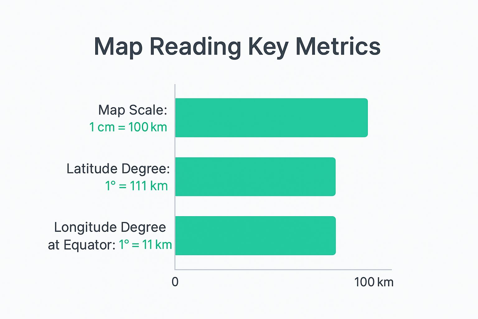
As you can see, things like the map scale and the degrees of latitude and longitude correspond directly to actual kilometers on the Earth's surface.
Decoding the Map’s Legend
Every good map uses a shorthand of symbols to represent real-world features, and the legend (or key) is your dictionary. It tells you what every line, color, and icon means.
- Political Boundaries: Dashed or solid lines are the classic way to show country or state borders.
- Physical Features: Colors and icons are used for mountains, rivers, deserts, and forests. You can almost always bet that a blue line is a river.
- Human-Made Structures: You’ll often see a star inside a circle to mark a capital city, or tiny airplane icons for airports.
Without the legend, a map is just abstract art. With it, you can instantly find the capital of Brazil, trace the Nile River from its source, or pinpoint the mighty Himalayan mountain range.
A map’s legend turns a collection of abstract symbols into a clear and readable narrative of the landscape. It’s the bridge between the representation and the reality, allowing you to see the world's features at a glance.
The Global Grid System Latitude and Longitude
Finally, you’ll notice that grid of faint lines covering the entire map. These are the lines of latitude and longitude, and they form a coordinate system that lets you find any precise location on Earth.
Latitude lines run horizontally, parallel to the equator, measuring how far north or south you are. Longitude lines run vertically, from pole to pole, measuring your distance east or west. Together, they create a unique "address" for any point on the planet.
This grid is the backbone of modern GPS and dictates everything from time zones to climate patterns. For a deeper dive, check out our guide on what are latitude and longitude. Getting comfortable with this system is what truly turns a flat map into a three-dimensional tool for exploration.
A Grand Tour of the Seven Continents
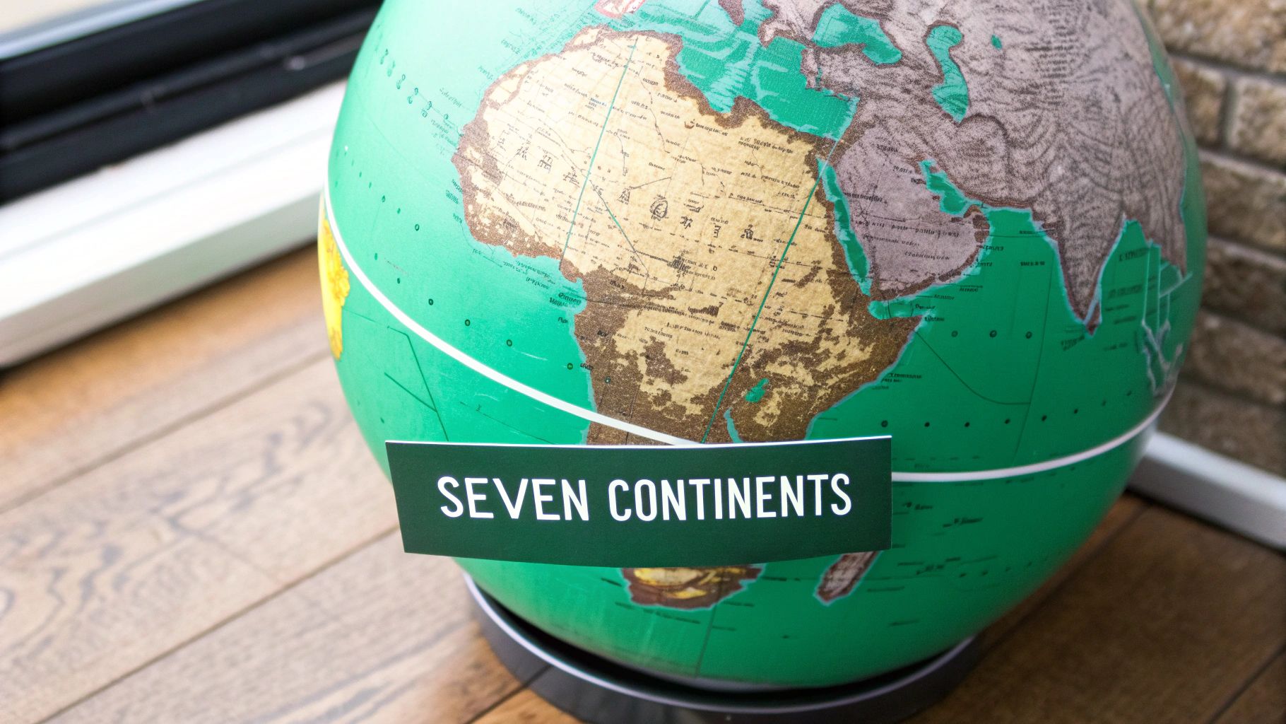
Alright, you've got the map-reading skills of a seasoned cartographer. Now, let's bring those landmasses to life. A world continents and oceans map isn't just a collection of shapes; it's a family portrait of seven incredibly diverse and dynamic places. Each continent has its own personality, a story carved out by billions of years of geology, climate, and human history.
This isn't your average tour. We're going beyond simple outlines and borders to explore the iconic features that define each continent—from towering mountain ranges and sprawling deserts to ancient wonders and modern megacities. Think of this as your pre-mission briefing before diving into a game like EarthChasers, where every location has a story waiting for you.
Asia: The Colossus of the East
Asia is a continent of superlatives. It’s not just the largest by land area, covering nearly 30% of the Earth’s land, but it's also the most populous by a staggering margin. The sheer scale is hard to wrap your head around, hosting everything from the frozen tundra of Siberia to the lush tropical rainforests of Southeast Asia.
This is a land of dramatic extremes. It boasts both the highest point on Earth, Mount Everest, and the lowest, the Dead Sea. This incredible geographic range has given rise to an equally stunning cultural mosaic. Asia is home to over 4.6 billion people—that's more than 60% of the world’s population—and some of the planet’s largest cities, like Shanghai (24.2 million), Delhi, and Tokyo. With over 2,300 distinct languages, its diversity is simply unmatched. You can dig into more of these fascinating geography facts from WorldAtlas.com.
Africa: The Cradle of Humanity
Stretching from the Mediterranean all the way down to the Cape of Good Hope, Africa is a continent of immense natural wealth and history that runs deeper than anywhere else. It's widely recognized as the birthplace of humanity, with a fossil record telling a story millions of years old.
You can't talk about Africa without mentioning its legendary features:
- The Sahara Desert: The largest hot desert in the world, a seemingly endless ocean of sand and rock.
- The Nile River: The longest river on the planet, whose fertile banks gave rise to one of the world's most ancient and awe-inspiring civilizations.
- The Great Rift Valley: A massive geological trench slicing through the eastern part of the continent, creating some of the most spectacular landscapes on Earth.
From the great migrations across the Serengeti to the vibrant cultures found in its 54 countries, Africa is a continent of rhythm, resilience, and breathtaking beauty.
The Americas: A New World of Wonders
Though we often talk about them separately, North and South America form one colossal landmass stretching from the Arctic Circle to the doorstep of Antarctica. These two continents, linked by the slender Isthmus of Panama, feature an incredible range of climates and ecosystems. For a deeper dive, check out our guide on what are the seven continents.
North America is defined by powerful economies and dramatic landscapes. Think of the jagged peaks of the Rocky Mountains, the vast Great Plains, and the ancient rock of the Canadian Shield.
South America, in contrast, is dominated by two natural giants: the Amazon Rainforest—the largest tropical rainforest on Earth—and the Andes, the world's longest mountain range.
Together, the Americas represent a "New World" that has profoundly shaped global culture, trade, and biodiversity ever since it reconnected with the rest of the globe centuries ago.
Europe: A Peninsula of Peninsulas
Europe might be the second-smallest continent, but its influence on world history is absolutely massive. It's often called a "peninsula of peninsulas" because of its long, jagged coastline. This intimate relationship with the sea fueled centuries of exploration, trade, and conflict.
Unlike other continents defined by vast, untamed wilderness, Europe’s landscape is a dense tapestry of cultures, languages, and historical sites. From the fjords of Norway and the ancient ruins of Greece to the bustling capitals of Paris and London, Europe packs an unbelievable amount of diversity into a relatively small space.
Australia and Antarctica: The Outliers
Finally, we land on the two continents sitting at the world's extremes.
- Australia: The smallest continent is also a single country. It’s famous for its vast, arid Outback, unique wildlife like kangaroos and koalas, and stunning coastal cities. Its long isolation led to the evolution of ecosystems you won't find anywhere else on the planet.
- Antarctica: The coldest, driest, and highest continent is a world made of ice. This polar desert is almost entirely covered by a colossal ice sheet holding about 70% of the world's fresh water. With no permanent human residents, it's a land dedicated to science and peace—one of the last true frontiers on our planet.
Quick Facts About the Seven Continents
For a quick at-a-glance comparison, here are the key stats for each continent. It's a great way to visualize the scale and diversity we've been talking about.
| Continent | Area (sq km) | Approx. Population | Highest Point | Number of Countries |
|---|---|---|---|---|
| Asia | 44,579,000 | 4.6 Billion | Mount Everest | 48 |
| Africa | 30,370,000 | 1.3 Billion | Mount Kilimanjaro | 54 |
| North America | 24,709,000 | 592 Million | Denali | 23 |
| South America | 17,840,000 | 434 Million | Aconcagua | 12 |
| Antarctica | 14,200,000 | ~1,000-5,000 | Vinson Massif | 0 |
| Europe | 10,180,000 | 746 Million | Mount Elbrus | 44 |
| Australia | 8,525,989 | 43 Million | Puncak Jaya | 14 (in Oceania) |
These numbers give you a solid framework, but they only scratch the surface. The real story of each continent is found in its people, its landscapes, and its history—all waiting for you to explore.
Navigating the Five Great Oceans
While the continents get most of the attention with their towering mountains and sprawling cities, it's the oceans that truly define our home. They aren't just the blue stuff on a world continents and oceans map; they are the planet's lifeblood. Think of it as one massive, interconnected global sea that drives our weather, regulates temperatures, and supports an incredible web of life.
The best way to understand this world ocean is not as five separate bodies of water, but as one gigantic system with five distinct "neighborhoods." Each of these basins—the Pacific, Atlantic, Indian, Southern, and Arctic—has its own personality, currents, and geological quirks. Getting to know them is essential to seeing the full geographic picture.
The Pacific Ocean: The Mighty Giant
The Pacific is the undisputed titan of the seas. It's so enormous that it covers more area than all the continents put together, hogging nearly a third of the Earth’s entire surface. When you glance at a map, its sheer scale is hard to wrap your head around, stretching from the Americas all the way to Asia and Australia.
But its size is just the start. The Pacific is also the deepest ocean, home to the Mariana Trench—a chasm plunging nearly 11 kilometers (about 7 miles) below sea level. The ocean is famously encircled by the Ring of Fire, a hotbed of volcanic and seismic activity where massive tectonic plates grind against each other. It’s a powerful reminder that the ocean floor is just as dynamic as the land we live on.
The Atlantic Ocean: The Great Conveyor Belt
Smaller than the Pacific but no less vital, the Atlantic Ocean acts like a massive global conveyor belt. It neatly separates the "Old World" of Europe and Africa from the "New World" of the Americas, and its currents have shaped human history for centuries, from legendary voyages to modern trade routes.
The Atlantic's most famous feature is the Gulf Stream, a powerful warm current flowing from the Gulf of Mexico up toward Europe. This current is basically a planetary heating system, delivering milder temperatures to Western Europe. Without it, countries like the UK would have a climate more like Canada’s.
The Atlantic Ocean shows just how deeply oceanic systems are tied to life on land. Its currents are a perfect example of our planet's interconnectedness, where a stream of water thousands of miles away decides whether a city gets a mild winter or a frozen one.
The Indian Ocean: The Tropical Crossroads
The Indian Ocean is unique, largely enclosed on three sides by Asia, Africa, and Australia. This geography makes it the warmest ocean in the world—a tropical basin that has served as a crossroads for maritime trade and cultural exchange for thousands of years.
Historically, its predictable monsoon winds created a reliable superhighway for sailors. These winds, which reverse direction twice a year, allowed traders to sail from Africa to India and back with amazing precision. Today, this ocean remains a vital artery for global commerce, connecting the Middle East, Africa, and East Asia with Europe and the Americas.
For a deeper dive into the nuances between oceans and seas, check out our guide on the oceans and seas of the world.
The Arctic and Southern Oceans: The Polar Regulators
At the top and bottom of our world are two oceans defined by ice. They might seem remote, but their health is absolutely critical to the stability of the entire planet.
The Arctic Ocean: The smallest and shallowest of the five, the Arctic is mostly covered by sea ice—though this is changing fast. It acts as the planet's air conditioner, reflecting sunlight back into space and helping keep global temperatures in check.
The Southern Ocean: Officially recognized as the fifth ocean in 2000, this body of water wraps around Antarctica. It’s defined by the mighty Antarctic Circumpolar Current, which flows completely unimpeded around the globe. This current acts as a barrier, keeping Antarctica's frigid waters separate from the warmer oceans to the north.
Together, these polar oceans are the heart of our planet's climate system. Their icy waters drive deep ocean currents that circulate nutrients and heat around the globe, making them essential for marine life everywhere.
All told, Earth’s oceans cover about 71% of the planet’s surface, with the remaining 29% being land. The Pacific Ocean alone is the largest basin, spanning roughly 155.6 million square kilometers and holding Earth's deepest point, the Mariana Trench. You can find more incredible insights about our planet's oceans on YouTube.
Exploring Continents and Oceans in a Digital Age
Embedded content
The maps we grew up with were static—beautifully drawn, sure, but ultimately flat. Today, the world continents and oceans map is alive on our screens, offering an incredible level of interaction that cartographers of old could only dream of.
Digital tools have completely changed how we see the world. We no longer just look at a map; we dive into it. With platforms like Google Earth, you can zoom from a satellite’s view of the entire planet down to a single street in seconds. This power to shift your perspective instantly gives you a sense of scale and connection that a paper map just can't match.
From Static Images to Dynamic Worlds
Think about the difference between a photograph of a mountain and actually being able to walk around it. That’s the leap we’ve made with digital mapping. Satellite imagery gives us stunning, true-to-life views of Earth, from the swirling patterns of hurricanes over the Atlantic to the intricate river deltas snaking across a continent.
This digital access has opened up exploration for everyone. You can virtually stand on the peak of Mount Everest, plunge into the Mariana Trench, or trace the Great Wall of China without leaving home. These tools turn geography from a list of facts to memorize into a rich, visual adventure that sparks genuine curiosity.
Digital maps transform us from spectators into explorers. They give us a hands-on interface to the world, letting us ask questions and find answers in a way that builds a natural love for geography.
Gamifying Geography for a New Generation
This is where educational games like EarthChasers really shine. They take the raw power of interactive mapping and wrap it in a layer of purpose and adventure. A game can turn a simple world continents and oceans map into a dynamic playground for discovery, making the whole process feel less like a lesson and more like a quest.
Instead of just pointing to a location, you might be challenged to:
- Navigate a trade route across the Indian Ocean, learning about historical monsoon winds along the way.
- Identify specific biomes in South America to find a rare species, getting a firsthand look at the continent's biodiversity.
- Solve a puzzle based on the capital cities of Europe, reinforcing political geography through active problem-solving.
This hands-on approach is incredibly effective. It taps into our natural desire to play and compete, building lasting geographic knowledge without you even realizing it. Learning the facts becomes a byproduct of a fun experience.
Making Geography Accessible and Exciting
Ultimately, the goal of these modern tools is to make geography more engaging than ever. For many of us, geography class meant staring at a pull-down map and memorizing names. Now, it’s about embarking on missions, discovering hidden landmarks, and competing with friends to see who knows the globe best.
Games like EarthChasers use this framework to build a strong foundation of knowledge. You learn to identify continents, oceans, countries, and major landmarks not through rote memorization, but through repeated, meaningful interactions inside the game. This method helps information stick in a way that feels natural and effortless.
The result is a new generation of geographers who see the world not just as a collection of places on a map, but as an interconnected system full of stories, challenges, and wonders. It’s an exciting shift that turns every one of us into an explorer, one mission at a time.
Answering Your Biggest World Geography Questions
Even after you've spent some time with a world continents and oceans map, a few tricky questions always seem to surface. Our planet is full of fascinating quirks that can trip up even the most experienced geography buffs. This section is all about tackling those common head-scratchers.
Think of it as your go-to guide for those "wait, why is it like that?" moments. We'll lay out clear, simple answers to build up your confidence as a global explorer—both on a real map and inside the world of EarthChasers.
Is Greenland a Continent?
This is easily one of the most common questions, and it’s a good one. On many maps—especially those using the classic Mercator projection—Greenland looks absolutely massive. It can even appear as large as Africa, which naturally makes people wonder if it's a continent.
The short answer is no, Greenland is not a continent. It’s actually just a very, very big island—the world's largest, in fact. Despite how it looks on a flat map, it’s officially part of North America. Here’s the kicker: Africa is more than 14 times larger than Greenland in reality.
Why Are Europe and Asia Separate Continents?
This question really gets to the core of what a "continent" even is. If you look at a globe, Europe and Asia are clearly part of one giant landmass, which geographers call Eurasia. There's no ocean or major sea dividing them, which is how we separate most other continents.
The split is almost entirely historical and cultural, not geological. The ancient Greeks were the first to make a distinction between Europe and Asia, and that tradition just stuck. The Ural Mountains in Russia are often used as a convenient dividing line, but that's a boundary created by humans, not by nature.
The separation of Europe and Asia is a perfect example of how our maps are shaped by more than just science. They reflect history and culture, telling a story about how we see our place in the world.
What's the Difference Between an Ocean and a Sea?
People often use "ocean" and "sea" as if they mean the same thing, but geographers see a clear difference. It all comes down to three things: size, depth, and where they are located.
- Oceans: These are the big five—the massive, primary bodies of saltwater that cover about 71% of Earth. They are incredibly deep and are not really enclosed by land.
- Seas: Seas are smaller bodies of saltwater that are either partially or completely surrounded by land. Good examples are the Mediterranean Sea, which is hugged by three continents, or the Caribbean Sea, which is nestled among islands.
A good way to remember it is that seas are often like huge bays or arms reaching out from the larger oceans.
Where Is Oceania and Is It a Continent?
Oceania is one of those terms that can cause a bit of a muddle. It's not a continent in the same way Australia is. Instead, Oceania is a much broader geographic region. It includes the continent of Australia plus the thousands of islands sprinkled across the Pacific Ocean.
Geographers usually break this vast, water-filled region into three main island groups:
- Melanesia: Home to islands like Fiji, New Guinea, and the Solomon Islands.
- Micronesia: A collection of smaller islands, including Guam and the Marshall Islands.
- Polynesia: Forms a huge triangle in the Pacific, with its corners at Hawaii, New Zealand, and Easter Island.
So, think of it this way: Australia is the continent, and Oceania is the entire neighborhood it lives in, along with all its island neighbors.
Ready to stop just reading about the world and start exploring it? EarthChasers turns the globe into an incredible 3D playground where you can see these continents and oceans for yourself. Launch your adventure today at https://earthchasers.com.