World geography trivia: 12 Surprising Questions
Explore world geography trivia with 12 surprising questions that sharpen your map skills and boost your global knowledge.
From towering peaks and sprawling cities to tiny, island nations, our world is filled with fascinating details and surprising facts. But how much of that information have you actually retained? It's time to put your knowledge to the ultimate test. We've compiled a list of challenging world geography trivia questions designed to separate the casual map-glancer from the true global explorer.
These aren't your average, run-of-the-mill questions. We are diving deep into common misconceptions, historical quirks, and mind-bending stats that might just change the way you see the planet. Each question is a chance to prove your expertise, but more importantly, to learn the intriguing stories behind the answers. Understanding these geographical details provides a richer context for global events, cultures, and the natural wonders that define our world.
This collection is your chance to expand your horizons and maybe even find your own travel inspiration for a future adventure, all from the comfort of your screen. As you challenge yourself, you'll uncover facts about everything from national capitals and unique borders to the planet's most extreme natural features. Ready to prove you're a geography whiz? Let's begin the journey.
1. What is the capital of Australia?
This classic piece of world geography trivia often stumps even seasoned travelers. While the iconic Sydney Opera House or the bustling laneways of Melbourne might come to mind first, neither is Australia's capital. The correct answer is Canberra, a city specifically designed and built for this role.
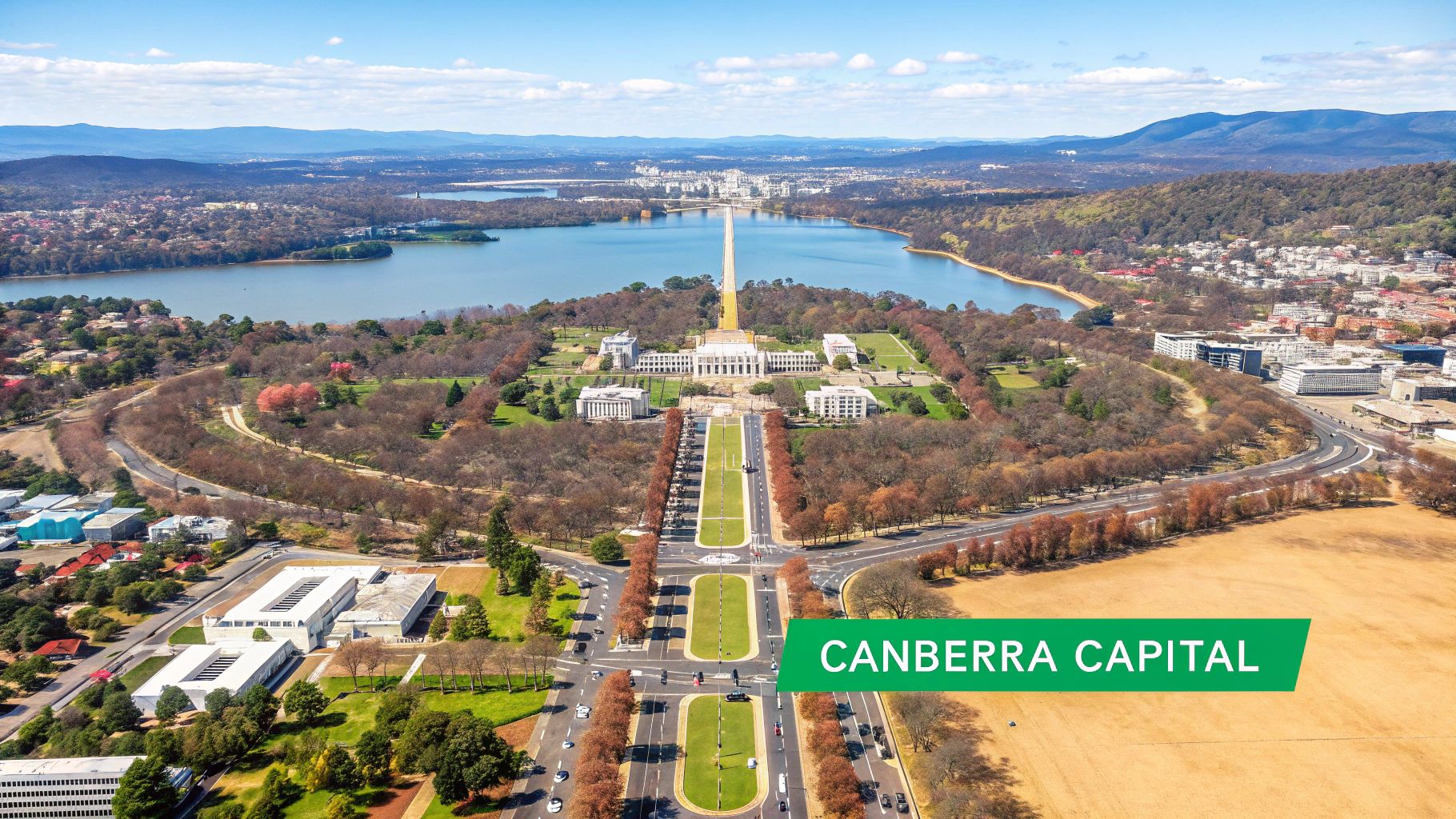
This question is a fantastic example of how a country's most populous or famous city isn't always its political center. In the early 20th century, a fierce rivalry between Sydney and Melbourne led to a compromise: building a new capital city between them.
Why This Trivia Matters
Understanding the story behind capitals like Canberra provides a deeper insight into a nation's history and politics. It challenges common assumptions and encourages a more nuanced view of the world.
- USA: A similar situation exists in the United States, where Washington, D.C. was established as the capital instead of a larger economic hub like New York City.
- Brazil: Brazil relocated its capital from Rio de Janeiro to the newly constructed city of Brasília in 1960 to help populate the country's interior.
A great tip is to remember that largest city ≠ capital city. This simple rule will help you correctly answer many geography questions. For a deeper dive, you can explore a complete map of world capitals to discover more planned cities and historical compromises.
2. Which country has the most time zones?
This is a fantastic piece of world geography trivia because the answer is so unexpected. While massive countries like Russia or the USA might seem like the obvious choice, the correct answer is France, which currently observes 12 different time zones.
Embedded content
This surprising fact is not due to France's mainland size but its numerous overseas territories and dependencies scattered across the globe. From French Polynesia in the Pacific Ocean to Réunion in the Indian Ocean, these territories place France in more time zones than any other nation.
Why This Trivia Matters
This question teaches an important lesson about geopolitics and history, showing how a country's global footprint extends far beyond its contiguous borders. It challenges us to think about the lasting legacy of colonial empires and the political status of territories worldwide.
- Russia: Russia has the most contiguous time zones, with 11 spanning its vast landmass.
- United Kingdom: The UK also has a high number of time zones (currently 8) due to its own overseas territories, including the Pitcairn Islands and Gibraltar.
A great tip is to remember that political boundaries > geographical size when it comes to time zones. Thinking about a country's global territories, not just its mainland, is the key to solving this and many other geography puzzles. For a full breakdown, you can explore a list of countries by number of time zones.
3. What is the only country that borders both the Atlantic and Indian Oceans?
This piece of world geography trivia tests your knowledge of continental positioning and maritime boundaries. The question requires pinpointing a nation with a unique coastal geography, and the answer is South Africa, strategically located at the southernmost tip of the African continent where two great oceans converge.
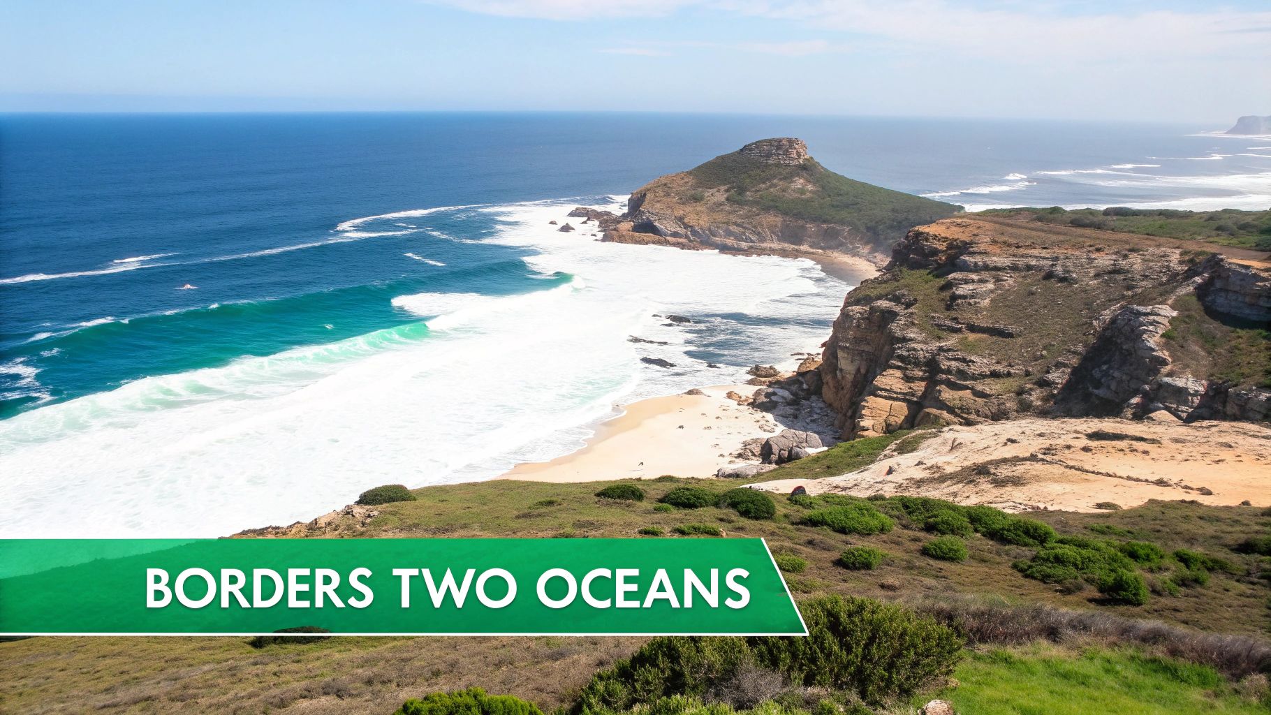
This question highlights how a country's physical location can define its history, economy, and ecological significance. South Africa's position has made it a critical point for global maritime trade for centuries, particularly around the famous Cape of Good Hope.
Why This Trivia Matters
Understanding the meeting points of major oceans provides insight into global trade routes, biodiversity, and climate patterns. It underscores the importance of coastal geography in shaping a nation's identity and strategic value.
- Cape Agulhas: This is the official geographic dividing point between the Atlantic and Indian Oceans, not the more famous Cape Point.
- Maritime History: The route around the Cape of Good Hope was pivotal during the Age of Discovery, connecting Europe with the East.
A helpful tip is to visualize Africa on a globe. Remembering that South Africa occupies the continent's extreme southern tip makes it the logical candidate. To explore more about the world's major water bodies, you can discover a complete guide to the oceans and seas of the world.
4. Which is the only country that has a single-color flag?
This fascinating piece of world geography trivia blends political history with vexillology, the study of flags. The answer is historical: from 1977 to 2011, Libya, under the rule of Muammar Gaddafi, adopted a solid green flag. This made it the only modern sovereign state with a national flag consisting of just one color and no design.
The plain green field was chosen by Gaddafi to symbolize his political philosophy and Libya's devotion to Islam. It remains a unique example of how a flag can represent a specific political era, often changing as the government does.
Why This Trivia Matters
Understanding the story behind Libya's former flag offers a powerful lesson in how national symbols evolve with political change. It highlights that a flag is not just a piece of cloth but a representation of identity, ideology, and a nation's history.
- Political Symbolism: The green flag was a direct reflection of Gaddafi's "Green Book" and his vision for the country.
- Post-Revolution Change: Following the 2011 Libyan Civil War and the fall of Gaddafi's regime, the country reverted to a red, black, and green tricolor flag, which was originally used from 1951 to 1969.
A great tip is to remember that national flags are dynamic symbols. They often change after major historical events like revolutions, independence, or shifts in political power.
5. What is the capital of Canada?
This piece of world geography trivia follows a similar pattern to our Australia question. While major hubs like Toronto, Vancouver, or Montréal might seem like obvious choices, Canada's capital is actually Ottawa. This city was deliberately chosen to serve as the nation's political heart.
The selection of Ottawa as the capital was a strategic political decision made by Queen Victoria in 1857. It served as a compromise, situated on the border between the predominantly English-speaking Upper Canada (now Ontario) and the French-speaking Lower Canada (now Quebec), bridging the two founding colonial cultures.
Why This Trivia Matters
Understanding why Ottawa is the capital reveals the delicate balance of Canada's history and its efforts to unify diverse populations. It underscores the theme that a capital city's role is often more about political and historical significance than economic or demographic dominance.
- Australia: Just like Canberra was a compromise between Sydney and Melbourne, Ottawa was a compromise between rival cities like Toronto and Montréal.
- Quebec: This pattern even exists at the provincial level. Montréal is Quebec's largest city, but the capital is the historically significant Quebec City.
A helpful tip is to remember that largest city ≠ capital city. Thinking about historical compromises can often lead you to the right answer. Beyond its capital, Canada offers diverse experiences; you can learn about the best time to visit Canada to plan a trip.
6. Which country is both in Europe and Asia?
This piece of world geography trivia challenges our understanding of continental divides, which are often as much about culture and politics as they are about pure geography. While a few countries fit the description, the most common and expected answer is Turkey, a nation famously straddling two continents.
The historic city of Istanbul is itself bisected by the Bosphorus strait, a waterway that serves as a physical boundary between the continents. This unique position places about 3% of Turkey's landmass in Southeast Europe (Thrace) and the remaining 97% in Western Asia (Anatolia).
Why This Trivia Matters
This question reveals that continental borders aren't always clear-cut lines on a map. These "transcontinental" countries often have incredibly rich histories and diverse cultures shaped by their unique geographic placement, serving as a bridge between different worlds.
- Russia: The most famous example, Russia's territory stretches from Eastern Europe all the way across Northern Asia to the Pacific Ocean.
- Kazakhstan: A portion of this Central Asian nation lies west of the Ural River, placing it geographically within Europe.
- Azerbaijan: Located in the Caucasus region, it is often considered to be at the crossroads of Eastern Europe and Western Asia.
A good tip for this type of question is to think about major geographical markers like the Ural Mountains or the Bosphorus strait. These features often serve as the dividing lines that give us such fascinating transcontinental nations.
7. What is the largest desert in the world?
This piece of world geography trivia flips a common assumption on its head. When thinking of deserts, most people picture vast, sun-scorched dunes. However, the largest desert in the world is actually the Antarctic Polar Desert, a frigid landscape defined by its extremely low precipitation.

This question is a brilliant geography lesson packed into a single fact. It teaches the fundamental scientific definition of a desert: a region that receives very little annual precipitation. Antarctica qualifies because, despite its ice sheet, it receives less than 200 millimeters (about 8 inches) of precipitation per year on average, with some areas receiving much less.
Why This Trivia Matters
Understanding this concept challenges our preconceived notions about climate and landscapes. It highlights that the key characteristic of a desert is its dryness, not its temperature, which is a critical distinction in geography.
- Sahara Desert: While not the overall largest, the Sahara is the world's largest hot desert, covering a massive portion of North Africa.
- Arctic Desert: Similar to its southern counterpart, the Arctic Polar Desert is the second-largest desert in the world, demonstrating the existence of cold deserts.
A great tip is to remember that low precipitation = desert. This simple rule helps differentiate between climate types and will give you an edge in any geography quiz. The distinction between "largest desert" (Antarctica) and "largest hot desert" (Sahara) is key.
8. Which is the smallest independent country in the world?
This piece of world geography trivia challenges our perception of what constitutes a country. When thinking of nations, we often picture vast landscapes, but the smallest sovereign state is actually a city-state located entirely within Rome, Italy. The correct answer is Vatican City.
Vatican City is minuscule, covering just 44 hectares (about 110 acres) with a population hovering around 800 people. It stands as definitive proof that a nation's sovereignty is not determined by its physical size or population count, but by its political independence and international recognition.
Why This Trivia Matters
Understanding microstates like Vatican City expands our knowledge of political geography and diverse forms of governance. It highlights the unique historical and political circumstances that can lead to the formation of a country, regardless of its dimensions.
- Monaco: Famous for its casino and Grand Prix, Monaco is the second-smallest country, covering just over 2 square kilometers.
- San Marino: Claiming to be the world's oldest republic, San Marino is another microstate completely surrounded by Italy, with an area of about 61 square kilometers.
A helpful tip is to remember that Vatican City is the smallest by both area and population. This unique status makes it a fascinating and memorable answer in any geography quiz.
9. What is the longest river in the world?
This is a cornerstone question in any world geography trivia quiz, challenging our knowledge of the planet's most significant natural features. While many might think of the mighty Amazon, the title for the longest river by distance belongs to the Nile River, which flows for approximately 4,130 miles (6,650 km).
This legendary river flows north through northeastern Africa, most famously through Egypt, where it has been the lifeblood of civilization for thousands of years. The debate between the Nile and the Amazon is a frequent topic, as the Amazon carries a far greater volume of water, but the Nile holds the record for length.
Why This Trivia Matters
Understanding the world's major river systems is fundamental to grasping global history, trade, and settlement patterns. Rivers like the Nile are not just lines on a map; they are the cradles of civilization and remain vital economic and agricultural arteries today.
- Amazon River: While second in length, it is the largest river by discharge volume, carrying more water than the next seven largest rivers combined.
- Yangtze River: The third-longest river in the world, it is the longest to flow entirely within one country (China) and is a critical part of its economy.
A great tip is to distinguish between length and volume. Remembering that the Nile is the longest and the Amazon is the largest by water volume will clarify this common point of confusion. The Nile's unique northward flow and its historical importance to ancient Egypt also make it a fascinating subject.
10. Which country has the most islands?
This is a tricky piece of world geography trivia because the answer hinges entirely on how you define an "island." While countries like Indonesia or Canada might seem like obvious contenders, the surprising champion by most official counts is Sweden, boasting an incredible archipelago.
Sweden is estimated to have between 221,800 and 267,570 islands. The vast majority are small, uninhabited skerries, but their sheer number is staggering, with the Stockholm archipelago alone containing around 30,000 islands.
Why This Trivia Matters
This question reveals the importance of definitions in geography. A country’s claim often depends on the minimum size requirement it uses to classify a piece of land as an island, which can range from just a few square meters to a more substantial area.
- Finland: A close Nordic neighbor, Finland also has a massive number of islands in the Baltic Sea, often claiming the top spot depending on the source.
- Norway: With its long, fjord-indented coastline, Norway also has an immense number of islands, estimated to be around 239,057.
- Canada: Home to the vast Arctic Archipelago, Canada has over 52,000 islands, including some of the world's largest.
A great tip is to remember that definitions are key. When this question comes up, asking "What's the minimum size for an island?" will show your expertise. Sweden is the most common answer, but the real trivia is knowing the debate itself.
11. What is the highest mountain in the world?
This is a cornerstone question in any world geography trivia challenge, testing foundational knowledge of Earth's most extreme features. While many can name it, the details are what make it truly fascinating. The correct answer is Mount Everest, soaring to 29,032 feet (8,849 meters) above sea level.
Located in the majestic Himalayan mountain range, Mount Everest straddles the border between Nepal and the Tibet Autonomous Region of China. It represents the planet's highest point and remains the ultimate goal for mountaineers worldwide, a true testament to nature's scale and power.
Why This Trivia Matters
This question opens the door to a more nuanced understanding of how we measure our world. The answer isn't as simple as it seems, as "highest" can be defined in different ways, challenging our perspective on geographic records.
- Mauna Kea: This dormant volcano in Hawaii is technically the world's tallest mountain from base to peak. Most of its massive 33,500 feet (10,210 meters) is submerged beneath the Pacific Ocean.
- Chimborazo: This peak in Ecuador is the farthest point from Earth's center. Due to the planet's equatorial bulge, its summit is farther into space than Everest's.
A great tip to remember is that measurement context is key. Everest is the highest based on elevation above sea level, but other mountains hold different "tallest" titles. This detail can win you the final point in a close trivia match.
12. Which country is the most populous in the world?
This is a piece of world geography trivia that has recently changed, catching many people by surprise. For centuries, the answer was China, but as of 2023, India has officially surpassed it to become the world's most populous nation, with a population exceeding 1.4 billion people.
This question highlights the dynamic nature of global demographics. The shift reflects decades of different population growth rates and family planning policies in the two countries. Together, India and China are home to more than one-third of the entire global population, making their demographic trends incredibly significant.
Why This Trivia Matters
Knowing which country is the most populous is more than just a fact; it's about understanding major shifts in global economics, culture, and geopolitics. A country's population size directly influences its labor force, consumer market, and international standing.
- China: Held the top spot for centuries, a key factor in its historical and modern influence.
- Indonesia: Ranks fourth globally with over 275 million people, making it a major power in Southeast Asia.
- Nigeria: As Africa's most populous country (and fifth in the world), its demographic boom is reshaping the continent.
A key tip is to remember that population rankings are not static. For a closer look at how populations are distributed across different land areas, you can explore the relationship between population and size by learning more about population density by country.
12-Question World Geography Comparison
| Question (Answer) | 🔄 Implementation complexity | ⚡ Resource requirements | 📊 Expected outcomes | 💡 Ideal use cases | ⭐ Key advantages |
|---|---|---|---|---|---|
| What is the capital of Australia? (Canberra) | Very low — single factual item | Minimal — map or source check | Corrects common misconception | Classroom warm-up; basic quizzes | ⭐ Highlights planned capital & political compromise |
| Which country has the most time zones? (France) | Low–moderate — requires territory awareness | Moderate — list of overseas territories/time zones | Shows political influence on timekeeping | Advanced quizzes; geopolitics lessons | ⭐ Reveals surprising geopolitical reach |
| Which country borders both the Atlantic and Indian Oceans? (South Africa) | Low — spatial reasoning needed | Minimal — globe/map reference | Reinforces coastal and maritime geography | Oceanography or map skills lessons | ⭐ Memorable due to unique coastal position |
| Which is the only country that has a single-color flag? (Libya — historically) | Low but time-sensitive (historical) | Minimal — historical flag sources | Teaches flag symbolism and political change | Vexillology or modern history topics | ⭐ Unusual, memorable historical fact |
| What is the capital of Canada? (Ottawa) | Very low — single factual item | Minimal — map or source check | Dispels assumption that largest city = capital | Intro geography; civic education | ⭐ Illustrates political compromise in capital selection |
| Which country is both in Europe and Asia? (Turkey) | Moderate — needs continental definition | Moderate — maps and geopolitical context | Explains transcontinental classification | Geopolitics; cultural geography | ⭐ Demonstrates strategic and cultural bridging |
| What is the largest desert in the world? (Antarctica) | Low but counterintuitive | Minimal — climate/precipitation data | Clarifies desert definition (precipitation-based) | Earth science; climate lessons | ⭐ Teaches non-intuitive scientific definitions |
| Which is the smallest independent country in the world? (Vatican City) | Very low — factual | Minimal — demographic/area data | Introduces microstates and sovereignty concepts | Political geography; statehood discussions | ⭐ Illustrates sovereignty independent of size |
| What is the longest river in the world? (The Nile River) | Low — straightforward (some debates exist) | Low — geographic references | Foundational physical geography knowledge | History, civilization, and geography lessons | ⭐ Historically and culturally significant fact |
| Which country has the most islands? (Sweden / depends on definition) | Moderate — depends on counting rules | Moderate — definitions and counts | Teaches importance of definitions in geography | Advanced geography; statistics discussions | ⭐ Encourages precision in geographic definitions |
| What is the highest mountain in the world? (Mount Everest) | Very low — well-established fact | Minimal — elevation sources | Core physical geography knowledge | Intro geography; mountaineering context | ⭐ Universally recognized geographic landmark |
| Which country is the most populous in the world? (India, as of 2023) | Low but time-sensitive | Moderate — up-to-date population data | Highlights recent demographic shift | Demography, current affairs, policy lessons | ⭐ Reflects major, recent global population change |
Ready to Become an EarthChaser?
So, how did you score? Whether you confidently navigated every question or discovered some surprising new facts, one thing is clear: our planet is a treasure trove of wonders. This journey through world geography trivia has likely reinforced that the world is far more complex and fascinating than we often assume. It’s easy to think of Canberra or Ottawa as simple answers on a quiz, but they are vibrant cities with unique histories. Similarly, knowing that France has the most time zones isn’t just a fun fact; it’s a direct reflection of its historical and geopolitical reach across the globe.
The trivia we’ve explored serves as a powerful reminder of the intricate connections that define our world. Understanding that the largest desert is actually the Antarctic Polar Desert, not a sandy expanse, challenges our preconceived notions and expands our definition of what a "desert" can be. Each question, from the smallest nation (Vatican City) to the country with the most islands (Sweden), peels back another layer of our planet's incredible diversity.
From Trivia Knowledge to True Understanding
Mastering these facts is more than just a way to impress your friends at the next trivia night. It's about developing a more profound global awareness. When you know these details, you start to see the world differently. You appreciate the immense scale of Mount Everest, understand the logistical complexities of a country spanning two continents like Turkey, and grasp the sheer geographical scope of a nation like South Africa, which touches two major oceans.
This knowledge fosters a deeper connection to the world and its people. It encourages curiosity and a desire to learn more about the cultures, ecosystems, and political landscapes that these geographical facts represent. This is the true power of world geography trivia: it acts as a gateway to a lifelong journey of discovery.
Your Next Step on the Global Adventure
If this collection of questions has sparked your inner explorer, why let the journey end here? The best way to make this knowledge stick is to see it, interact with it, and experience it. Reading about the world is one thing, but immersing yourself in it is another. You can transform your passion for geography from a passive hobby into an active adventure.
Don’t just memorize the facts; bring them to life. Imagine virtually standing at the peak of Everest or navigating the thousands of islands in Sweden's archipelago. This is where your adventure truly begins. By engaging with these locations in an interactive way, you build a stronger, more lasting connection to the amazing world we all share.
Ready to turn your trivia knowledge into a real adventure? EarthChasers lets you explore the globe, compete in challenges, and see the places you've just read about in stunning 3D. Download the game and start your journey today at EarthChasers.